Hudson Bay is just freezing over now. That particular ice is very thin at the moment and thus the coverage area could be fluctuating extensively. A good prediction would be that the two sources will soon agree with each other.
December 1st and June 1st are dates where you’ll see large jumps in extent. Some data keepers (and where you get yours from, most likely) update their algorithms on those dates to account for differing ice stage during summer and winter. After June 1st, when there’s flooded ice, melt ponds, rotten ice, etc., microwave emissivity is much different than that of actual sea-ice and satellites “see” it as open water. But there are minute differences between those areas of flooded sea-ice and actual SIF waters, so they apply a slightly different algorithm to try and account for such areas.
CIS only show their maps now for navigation purposes for marine. On Hudson’s Bay and James Bay there is nowhere with open water left near and a town, island etc. so they have quit producing the maps last week.
Now resolved: as of December 4, it got corrected. I’m assuming it was a correction rather than a huge jump in ice formation since as I said above, NISDC had been showing above-average extent for HB for days (and HB seemed to be the only outlier).

CIS shows little ice over Hudson Bay http://www.ec.gc.ca/glaces-ice/default.asp?lang=En&n=542306E5-1
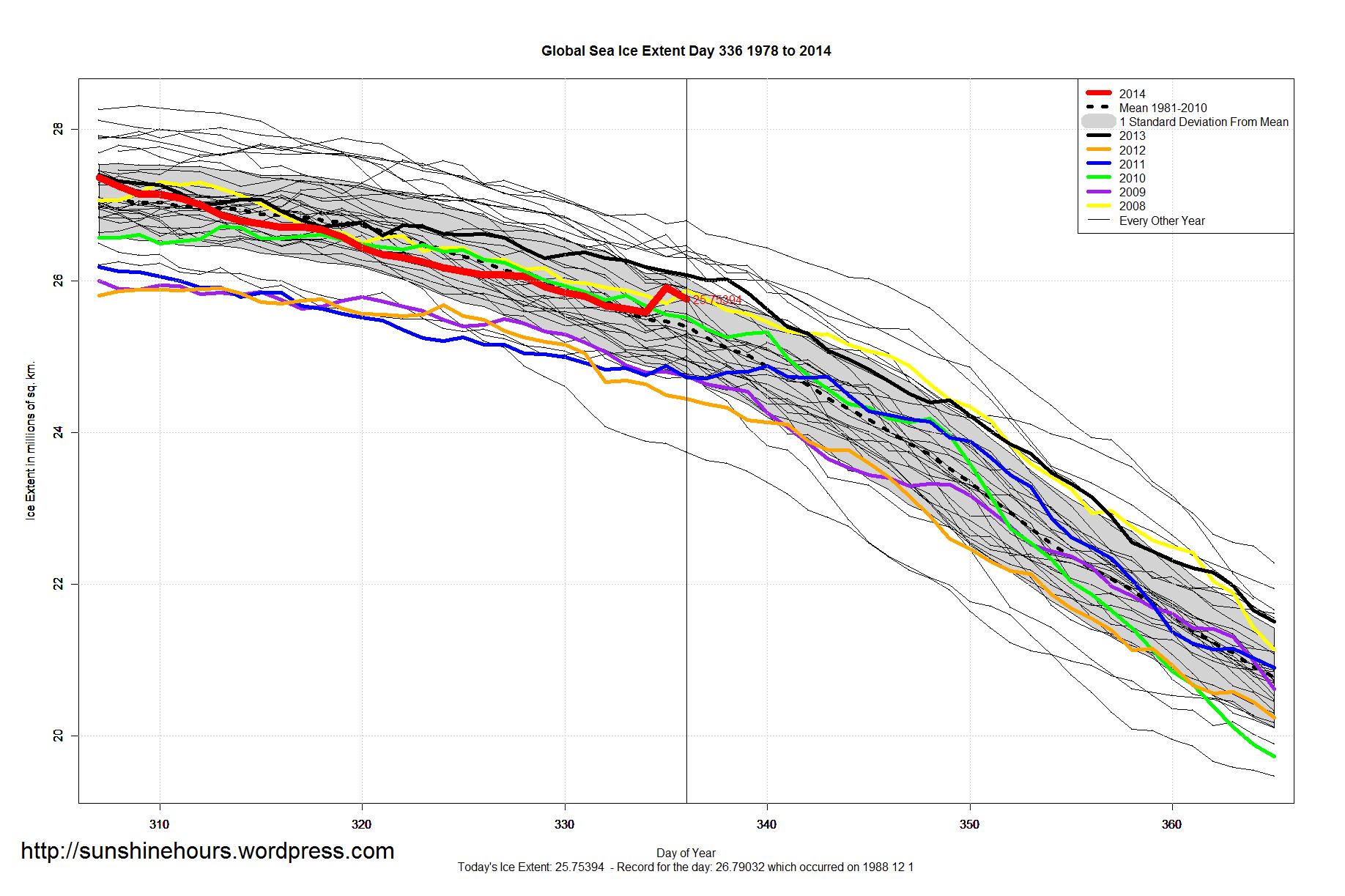
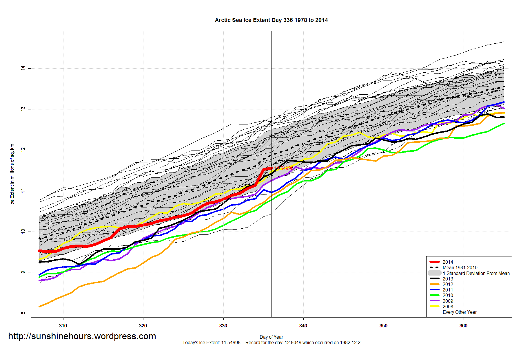
NSIDC shows way-above-average ice on Hudson Bay http://nsidc.org/data/seaice_index/images/daily_images/N_daily_extent_hires.png
Other regions seem to be similar, like Davis Strait.
Any thoughts?
Susan
Not sure. Life has gotten in the way of me paying a lot of attention to what is going on. In a good way.
Hudson Bay is just freezing over now. That particular ice is very thin at the moment and thus the coverage area could be fluctuating extensively. A good prediction would be that the two sources will soon agree with each other.
OK, glad to hear it! Thanks anyway.
Susan
December 1st and June 1st are dates where you’ll see large jumps in extent. Some data keepers (and where you get yours from, most likely) update their algorithms on those dates to account for differing ice stage during summer and winter. After June 1st, when there’s flooded ice, melt ponds, rotten ice, etc., microwave emissivity is much different than that of actual sea-ice and satellites “see” it as open water. But there are minute differences between those areas of flooded sea-ice and actual SIF waters, so they apply a slightly different algorithm to try and account for such areas.
CIS only show their maps now for navigation purposes for marine. On Hudson’s Bay and James Bay there is nowhere with open water left near and a town, island etc. so they have quit producing the maps last week.
Now resolved: as of December 4, it got corrected. I’m assuming it was a correction rather than a huge jump in ice formation since as I said above, NISDC had been showing above-average extent for HB for days (and HB seemed to be the only outlier).
See below: http://polarbearscience.com/2014/12/04/hudson-bay-sea-ice-above-average-for-this-date-more-good-news-for-polar-bears/