USCRN TMax/Tmin/Tmean October 2013 – Russia is Warming at 225F / Century?

The USCRN is the US Climate Research Network. I had not looked at the data in a little while. So I was confused by the state code of SA.

Well, it turned out that the NOAA has added a station in Tiksi, Russia. Which has been warming (Tmax) at 225F/century over the last 3 Octobers.

The USCRN has no stations in Connecticut or Delaware or New Jersey, but it now has one in Russia.  Bizarre.

Anyway, the data is not that old, but here is the USCRN Tmax, Tmean and Tmin trends for October for most of the states in the USA and Tiksi.

Click for bigger.

Tmax
USCRN Max October data up to 201311

Tmean
USCRN Mean October data up to 201311

Tmin
USCRN Min October data up to 201311

USCRN April 2013 – 41 to 9 ratio of coldest Aprils to Warmest April

The USCRN is a new ‘state of the art’ United States Climate Reference Network.

There are 222 stations of which 220 have data for April 2013. Of those 222, only 137 have 5 or more years of data. I’ll be using the 137 list.

41 of those 137 had April 2013 as the coldest April.

9 of those 137 had April 2013 as the warmest April.

Stations with April as Coldest

State Stn Years of Data April 2013 AVG in C Coldest April Coldest April AVG in C Coldest 5 Aprils
AK Fairbanks_11_NE 11 -7.1 2013 -7.1 2013,2006,2008,2011,2009
AK Sitka_1_NE 8 3.1 2013 3.1 2013,2008,2006,2009,2007
AK St._Paul_4_NE 8 -4.2 2013 -4.2 2013,2012,2010,2006,2009
AL Brewton_3_NNE 6 17.7 2013 17.7 2013,2009,2008,2010,2012
AL Russellville_4_SSE 7 14.8 2013 14.8 2013,2008,2009,2012,2010
AL Thomasville_2_S 6 17.1 2013 17.1 2013,2009,2008,2010,2012
CO Boulder_14_W 10 -3.2 2013 -3.2 2013,2008,2011,2010,2009
CO La_Junta_17_WSW 9 8 2013 8 2013,2007,2005,2008,2009
CO Nunn_7_NNE 10 3.5 2013 3.5 2013,2009,2008,2011,2007
IL Shabbona_5_NNE 10 7.4 2013 7.4 2013,2007,2009,2011,2008
KS Manhattan_6_SSW 10 10.1 2013 10.1 2013,2008,2007,2009,2004
KS Oakley_19_SSW 8 7.8 2013 7.8 2013,2007,2008,2009,2011
MI Chatham_1_SE 9 1.2 2013 1.2 2013,2007,2011,2009,2008
MI Gaylord_9_SSW 6 2.5 2013 2.5 2013,2011,2009,2012,2008
MN Goodridge_12_NNW 10 -0.2 2013 -0.2 2013,2008,2004,2007,2009
MN Sandstone_6_W 6 2.2 2013 2.2 2013,2008,2011,2009,2012
MO Chillicothe_22_ENE 8 9.9 2013 9.9 2013,2008,2007,2009,2011
MO Joplin_24_N 6 11.7 2013 11.7 2013,2008,2009,2011,2010
MS Holly_Springs_4_N 6 14.6 2013 14.6 2013,2008,2009,2012,2010
MT Wolf_Point_29_ENE 12 1.5 2013 1.5 2013,2002,2011,2008,2009
MT Wolf_Point_34_NE 12 0.7 2013 0.7 2013,2002,2011,2009,2008
ND Jamestown_38_WSW 5 -1.1 2013 -1.1 2013,2009,2011,2012,2010
ND Medora_7_E 9 1.4 2013 1.4 2013,2011,2009,2007,2008
ND Northgate_5_ESE 7 -3.8 2013 -3.8 2013,2011,2009,2008,2007
NE Harrison_20_SSE 10 3.2 2013 3.2 2013,2009,2008,2011,2007
NE Lincoln_8_ENE 12 7.9 2013 7.9 2013,2008,2007,2009,2011
NE Lincoln_11_SW 12 7.9 2013 7.9 2013,2008,2009,2007,2011
NE Whitman_5_ENE 9 4 2013 4 2013,2008,2011,2009,2007
OK Goodwell_2_E 10 9.6 2013 9.6 2013,2007,2005,2009,2008
OK Stillwater_2_W 12 12.5 2013 12.5 2013,2007,2008,2009,2004
OK Stillwater_5_WNW 12 12.2 2013 12.2 2013,2007,2008,2009,2004
ON Egbert_1_W 9 4.8 2013 4.8 2013,2007,2012,2011,2009
SD Aberdeen_35_WNW 6 0.3 2013 0.3 2013,2008,2011,2009,2012
SD Buffalo_13_ESE 9 2.4 2013 2.4 2013,2009,2008,2011,2007
SD Pierre_24_S 7 2.9 2013 2.9 2013,2009,2011,2008,2007
SD Sioux_Falls_14_NNE 11 3.2 2013 3.2 2013,2008,2011,2009,2007
TX Austin_33_NW 6 17.2 2013 17.2 2013,2010,2009,2008,2012
TX Port_Aransas_32_NNE 6 19.7 2013 19.7 2013,2010,2008,2009,2012
WI Necedah_5_WNW 9 4.8 2013 4.8 2013,2011,2007,2008,2009
WY Lander_11_SSE 9 3.4 2013 3.4 2013,2009,2008,2011,2010
WY Sundance_8_NNW 6 -0.8 2013 -0.8 2013,2011,2008,2009,2010

Stations with April as Warmest.

State Stn Years of Data April 2013 AVG in C Warmest April Warmest April AVG in C Warmest 5 Aprils
AZ Yuma_27_ENE 6 23.4 2013 23.4 2013,2012,2008,2011,2009
CA Fallbrook_5_NE 6 15.2 2013 15.2 2013,2009,2011,2012,2010
CA Merced_23_WSW 10 16.7 2013 16.7 2013,2004,2007,2012,2009
CA Redding_12_WNW 11 15.4 2013 15.4 2013,2004,2007,2009,2012
CA Stovepipe_Wells_1_SW 9 27.1 2013 27.1 2013,2007,2012,2008,2011
CA Yosemite_Village_12_W 6 8.1 2013 8.1 2013,2012,2008,2009,2011
HI Hilo_5_S 8 20.8 2013 20.8 2013,2011,2008,2007,2010
NV Mercury_3_SSW 10 17.8 2013 17.8 2013,2007,2012,2004,2008
OR Corvallis_10_SSW 7 10.2 2013 10.2 2013,2012,2007,2009,2010

USCRN vs NOAA September 2012

USCRN vs NOAA September 2012 update.

The USCRN is a new ‘state of the art’ United States Climate Reference Network. The USCRN “consists of 114 stations developed, deployed, managed, and maintained by the National Oceanic and Atmospheric Administration (NOAA) in the continental United States for the express purpose of detecting the national signal of climate change.”

This is the monthly Mean from both NOAA and USCRN for September 2012 for the 48 continental states.

16 states show USCRN stations warmer than NOAA (bold) and 32 show NOAA warmer than USCRN.

NOAA – USCRN = NOAA state temperature average minus USCRN state temperature average.

Ignoring area weighting, the NOAA temperature averaged 0.80F warmer than USCRN.

State NOAA USCRN NOAA – USCRN
Alabama 73 71.72 1.28
Arizona 73.7 74.61 -0.91
Arkansas 73.1 71.24 1.86
California 72.7 72.37 0.33
Colorado 59.6 59.76 -0.16
Florida 79.5 80.36 -0.86
Georgia 74.1 74.97 -0.87
Idaho 59.3 61.88 -2.58
Illinois 64.7 61.52 3.18
Indiana 64.1 64.76 -0.66
Iowa 61.8 63.14 -1.34
Kansas 67.6 66.02 1.58
Kentucky 67 67.19 -0.19
Louisiana 77.2 75.83 1.37
Maine 56.4 55.58 0.82
Michigan 58.5 54.86 3.64
Minnesota 57.1 54.23 2.87
Mississippi 74.2 71.24 2.96
Missouri 66.7 65.84 0.86
Montana 58.4 55.72 2.68
Nebraska 63.4 62.83 0.57
Nevada 65.4 67.52 -2.12
New Hampshire 58.3 59.45 -1.15
New Mexico 66.1 64.17 1.93
New York 60 59.63 0.37
North Carolina 69.8 66.26 3.54
North Dakota 57.2 57.98 -0.78
Ohio 63.2 62.24 0.96
Oklahoma 74.1 71.73 2.37
Oregon 60.9 61.34 -0.44
Pennsylvania 62.3 64.4 -2.1
Rhode Island 62.9 61.88 1.02
South Carolina 73.4 74.03 -0.63
South Dakota 62.5 61.34 1.16
Tennessee 69 64.22 4.78
Texas 76.7 76.84 -0.14
Utah 64.1 63.75 0.35
Virginia 67.1 68.36 -1.26
Washington 60.6 58.28 2.32
West Virginia 64 57.2 6.8
Wisconsin 57.8 57.56 0.24
Wyoming 58.3 58.22 0.08

USCRN vs NOAA August 2012

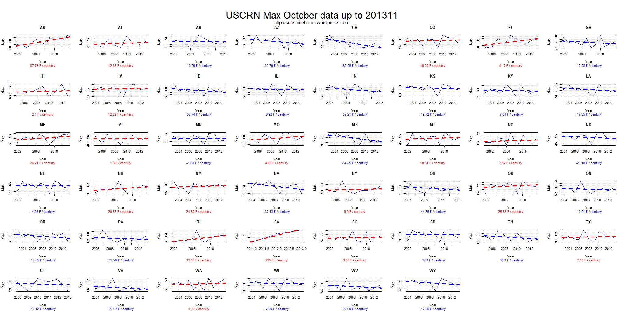
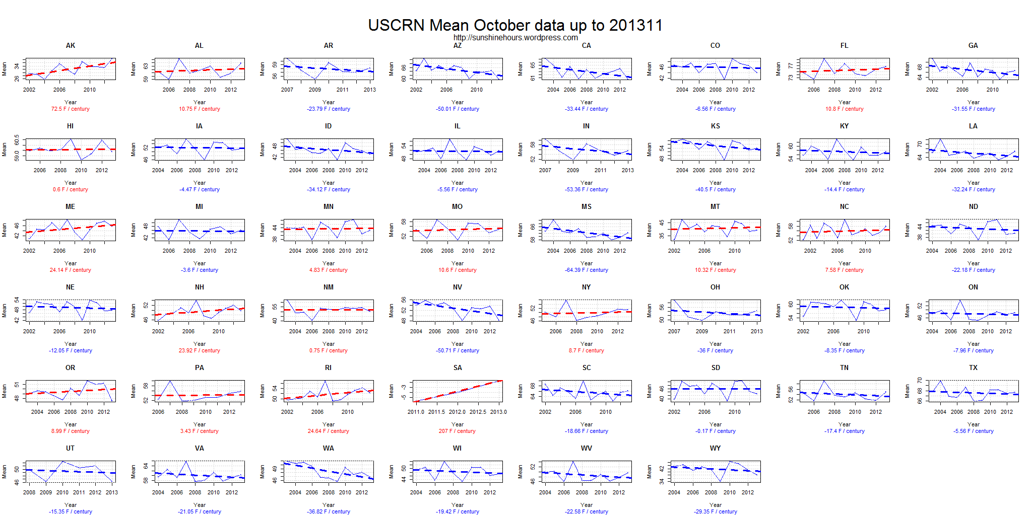
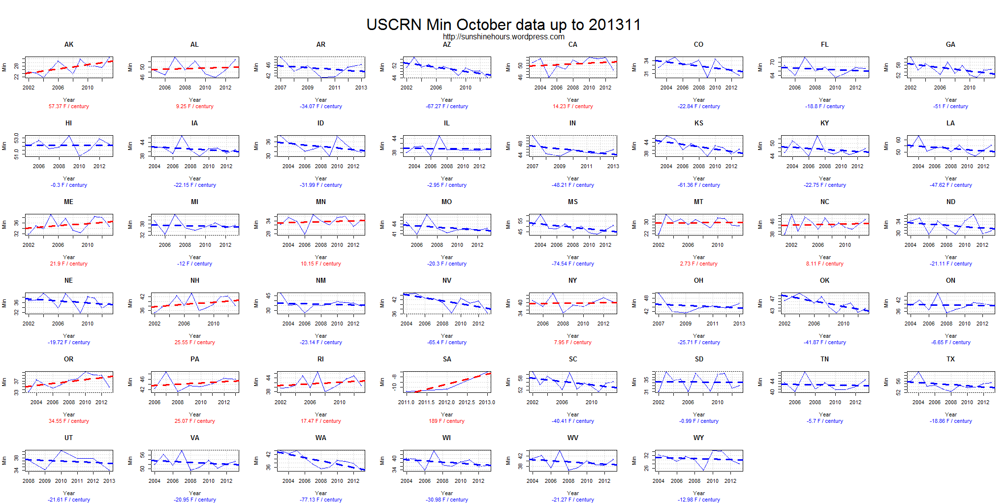
USCRN vs NOAA August 2012 update. (I’m late because USCRN didn’t post August monthly temperatures until October 3rd after they posted September data).

The USCRN is a new ‘state of the art’ United States Climate Reference Network. The USCRN “consists of 114 stations developed, deployed, managed, and maintained by the National Oceanic and Atmospheric Administration (NOAA) in the continental United States for the express purpose of detecting the national signal of climate change.”

This is the monthly Mean from both NOAA and USCRN for August 2012 for the 48 continental states.

14 states show USCRN stations warmer than NOAA (bold) and 34 show NOAA warmer than USCRN.

NOAA – USCRN = NOAA state temperature average minus USCRN state temperature average.

Ignoring area weighting, the NOAA temperature averaged 0.83F warmer than USCRN.

State NOAA USCRN NOAA – USCRN
Alabama 78.3 77.37 0.93
Arizona 80.8 81.62 -0.82
Arkansas 80 78.44 1.56
California 77.5 75.56 1.94
Colorado 67.9 68.57 -0.67
Florida 81.6 82.04 -0.44
Georgia 78.3 78.75 -0.45
Idaho 68.5 71.24 -2.74
Illinois 73.5 69.62 3.88
Indiana 71.8 74.3 -2.5
Iowa 70.9 71.24 -0.34
Kansas 76.2 75.38 0.82
Kentucky 74.3 74.66 -0.36
Louisiana 81.8 81.14 0.66
Maine 68 67.37 0.63
Michigan 67.5 64.94 2.56
Minnesota 66.5 64.04 2.46
Mississippi 79.3 77.63 1.67
Missouri 76.4 75.08 1.32
Montana 67.2 64.26 2.94
Nebraska 72.6 72.09 0.51
Nevada 73.9 74.9 -1
New Hampshire 68.8 70.25 -1.45
New Mexico 73.9 72.19 1.71
New York 68.7 68.36 0.34
North Carolina 75.7 71.96 3.74
North Dakota 66.8 66.62 0.18
Ohio 71.6 71.42 0.18
Oklahoma 81.3 79.97 1.33
Oregon 67.6 66.74 0.86
Pennsylvania 70.2 72.86 -2.66
Rhode Island 71.8 70.34 1.46
South Carolina 77.9 77.54 0.36
South Dakota 70.9 69.84 1.06
Tennessee 75.5 69.98 5.52
Texas 83.7 83.82 -0.12
Utah 74.1 73.26 0.84
Virginia 74.3 75.65 -1.35
Washington 67.8 64.46 3.34
West Virginia 70.9 63.68 7.22
Wisconsin 67.3 68.36 -1.06
Wyoming 67.6 66.62 0.98

NOAA vs USCRN July 2012

The USCRN is a new ‘state of the art’ United States Climate Reference Network.

The USCRN “consists of 114 stations developed, deployed, managed, and maintained by the National Oceanic and Atmospheric Administration (NOAA) in the continental United States for the express purpose of detecting the national signal of climate change.”

This is the monthly Mean from both NOAA and USCRN for July 2012 for the 48 continental states.

9 states show USCRN stations warmer than NOAA (bold) and 39 show NOAA warmer than USCRN.

State NOAA USCRN NOAA_minus_USCRN
Alabama 81.7 80.83 0.87
Arizona 80.3 81.41 -1.11
Arkansas 84.1 84.2 -0.1
California 75 72.32 2.68
Colorado 71.2 71.29 -0.09
Florida 82.2 81.56 0.64
Georgia 82.3 82 0.3
Idaho 70.2 71.96 -1.76
Illinois 81.7 77.54 4.16
Indiana 80.2 81.68 -1.48
Iowa 79.4 80.06 -0.66
Kansas 84.3 84.02 0.28
Kentucky 80.7 80.24 0.46
Louisiana 82.1 82.04 0.06
Maine 68 66.74 1.26
Michigan 73.3 68.9 4.4
Minnesota 74.4 70.52 3.88
Mississippi 81.8 80.15 1.65
Missouri 83.7 82.04 1.66
Montana 71.4 67.89 3.51
Nebraska 80 79.47 0.53
Nevada 73.6 73.52 0.08
New Hampshire 69.6 70.61 -1.01
New Mexico 74.6 72.91 1.69
New York 71.7 71.15 0.55
North Carolina 80.5 76.52 3.98
North Dakota 73.8 73.16 0.64
Ohio 77.6 76.28 1.32
Oklahoma 85.5 84.78 0.72
Oregon 67.4 66.42 0.98
Rhode Island 73.1 71.87 1.23
South Carolina 82.7 81.86 0.84
South Dakota 78.8 77.86 0.94
Tennessee 80.4 75.92 4.48
Texas 83.4 82.76 0.64
Utah 74.2 74.03 0.17
Virginia 79 80.24 -1.24
Washington 66.6 63.44 3.16
West Virginia 75.5 68 7.5
Wisconsin 74.7 76.64 -1.94
Wyoming 71.5 69.98 1.52

USCRN TMAX off a cliff – as of July 2012

Anthony Watt from WUWT mentioned the USCRN in a recent post.

The USCRN is a new ‘state of the art’ United States Climate Reference Network.

So, I thought I would take a look at the monthly TMAX data (T_MONTHLY_MAX). I downloaded all the monthly files.

If there was enough data: I calculated an anomaly for each month for each station based on 2005 to 2009 mean. Yes, thats a short period, but the USCRN hasn’t been around long. I graphed the data. And I calculated the Trend for data from 2007 on.

Here is the trend for each station (with enough data) sorted by highest trend to lowest.  There are a few graphs at the bottom.

The mean of the trends was -2.34F / Decade

State Station Start yyyymm End yyyymm Trend
31 CA Redding_12_WNW 200701 201207 4.31
29 CA Fallbrook_5_NE 200804 201207 3.41
33 CA Stovepipe_Wells_1_SW 200701 201207 2.46
30 CA Merced_23_WSW 200701 201207 2.15
34 CA Yosemite_Village_12_W 200709 201207 1.96
104 OR Corvallis_10_SSW 200701 201207 1.74
75 MT St._Mary_1_SSW 200701 201207 1.61
48 HI Hilo_5_S 200701 201207 1.55
AK Barrow_4_ENE 200701 201207 1.53
52 ID Murphy_10_W 200701 201207 1.50
95 NV Mercury_3_SSW 200701 201207 1.46
32 CA Santa_Barbara_11_W 200808 201207 1.39
135 WY Moose_1_NNE 200701 201207 1.37
51 ID Arco_17_SW 200701 201207 1.28
106 OR Riley_10_WSW 200701 201207 1.13
3 AK St._Paul_4_NE 200701 201207 1.13
129 WA Darrington_21_NNE 200701 201207 1.11
105 OR John_Day_35_WNW 200701 201207 0.90
130 WA Quinault_4_NE 200701 201207 0.81
103 OR Coos_Bay_8_SW 200808 201207 0.49
94 NV Denio_52_WSW 200806 201207 0.44
27 AZ Yuma_27_ENE 200803 201207 0.41
49 HI Mauna_Loa_5_NNE 200701 201207 0.39
93 NV Baker_5_W 200701 201207 0.21
28 CA Bodega_6_WSW 200806 201207 -0.13
76 MT Wolf_Point_29_ENE 200701 201207 -0.15
1 AK Fairbanks_11_NE 200701 201207 -0.28
131 WA Spokane_17_SSW 200708 201207 -0.38
17 AL Selma_6_SSE 200703 201207 -0.41
25 AZ Tucson_11_W 200701 201207 -0.42
117 TX Austin_33_NW 200802 201207 -0.46
22 AL Valley_Head_1_SSW 200701 201207 -0.51
26 AZ Williams_35_NNW 200806 201207 -0.52
83 ND Northgate_5_ESE 200701 201207 -0.62
77 MT Wolf_Point_34_NE 200701 201207 -0.76
8 AL Fairhope_3_NE 200701 201207 -0.76
12 AL Guntersville_2_SW 200701 201207 -0.76
134 WY Lander_11_SSE 200701 201207 -0.79
10 AL Gainesville_2_NE 200703 201207 -0.82
9 AL Gadsden_19_N 200701 201207 -0.83
5 AL Clanton_2_NE 200703 201207 -0.85
7 AL Cullman_3_ENE 200701 201207 -0.86
6 AL Courtland_2_WSW 200701 201207 -0.90
2 AK Sitka_1_NE 200701 201207 -0.92
16 AL Scottsboro_2_NE 200701 201207 -0.94
41 FL Everglades_City_5_NE 200702 201207 -0.95
14 AL Muscle_Shoals_2_N 200704 201207 -1.03
79 NC Asheville_13_S 200701 201207 -1.03
46 GA Newton_11_SW 200701 201207 -1.03
37 CO Dinosaur_2_E 200701 201207 -1.13
124 TX Port_Aransas_32_NNE 200711 201207 -1.14
15 AL Russellville_4_SSE 200701 201207 -1.15
126 UT Torrey_7_E 200710 201207 -1.21
44 GA Brunswick_23_S 200701 201207 -1.23
43 FL Titusville_7_E 200701 201207 -1.27
80 NC Durham_11_W 200703 201207 -1.34
116 TN Crossville_7_NW 200701 201207 -1.37
35 CO Boulder_14_W 200701 201207 -1.43
111 SC McClellanville_7_NE 200701 201207 -1.43
82 ND Medora_7_E 200701 201207 -1.47
36 CO Cortez_8_SE 200701 201207 -1.55
45 GA Newton_8_W 200701 201207 -1.55
72 MS Newton_5_ENE 200701 201207 -1.58
114 SD Pierre_24_S 200701 201207 -1.59
78 NC Asheville_8_SSW 200701 201207 -1.76
42 FL Sebring_23_SSE 200712 201207 -1.85
110 SC Blackville_3_W 200701 201207 -1.85
18 AL Selma_13_WNW 200701 201207 -1.89
11 AL Greensboro_2_WNW 200703 201207 -1.96
92 NM Socorro_20_N 200701 201207 -1.98
91 NM Los_Alamos_13_W 200701 201207 -2.02
113 SD Buffalo_13_ESE 200701 201207 -2.05
128 VA Charlottesville_2_SSE 200703 201207 -2.05
60 LA Lafayette_13_SE 200701 201207 -2.06
39 CO Montrose_11_ENE 200701 201207 -2.09
58 KY Bowling_Green_21_NNE 200701 201207 -2.13
47 GA Watkinsville_5_SSE 200701 201207 -2.32
127 VA Cape_Charles_5_ENE 200701 201207 -2.33
24 AZ Elgin_5_S 200701 201207 -2.46
59 KY Versailles_3_NNW 200701 201207 -2.55
107 PA Avondale_2_N 200701 201207 -2.57
90 NM Las_Cruces_20_N 200702 201207 -2.62
84 NE Harrison_20_SSE 200701 201207 -3
21 AL Troy_2_W 200801 201207 -3.04
119 TX Edinburg_17_NNE 200701 201207 -3.09
4 AL Brewton_3_NNE 200801 201207 -3.13
108 RI Kingston_1_NW 200701 201207 -3.15
109 RI Kingston_1_W 200701 201207 -3.23
125 UT Brigham_City_28_WNW 200708 201207 -3.28
63 ME Old_Town_2_W 200701 201207 -3.32
96 NY Ithaca_13_E 200701 201207 -3.42
20 AL Thomasville_2_S 200801 201207 -3.56
61 LA Monroe_26_N 200701 201207 -3.77
62 ME Limestone_4_NNW 200701 201207 -3.77
88 NH Durham_2_N 200701 201207 -3.79
102 ON Egbert_1_W 200701 201207 -3.83
133 WV Elkins_21_ENE 200701 201207 -3.87
98 OH Coshocton_8_NNE 200701 201207 -3.91
97 NY Millbrook_3_W 200701 201207 -4.10
123 TX Panther_Junction_2_N 200702 201207 -4.10
121 TX Muleshoe_19_S 200701 201207 -4.12
89 NH Durham_2_SSW 200701 201207 -4.18
40 CO Nunn_7_NNE 200701 201207 -4.21
87 NE Whitman_5_ENE 200701 201207 -4.28
122 TX Palestine_6_WNW 200701 201207 -4.38
64 MI Chatham_1_SE 200701 201207 -4.42
112 SD Aberdeen_35_WNW 200706 201207 -4.55
74 MT Lewistown_42_WSW 200807 201207 -4.61
23 AR Batesville_8_WNW 200701 201207 -4.83
132 WI Necedah_5_WNW 200701 201207 -4.83
68 MO Chillicothe_22_ENE 200701 201207 -4.88
120 TX Monahans_6_ENE 200701 201207 -4.99
85 NE Lincoln_8_ENE 200701 201207 -4.99
73 MT Dillon_18_WSW 200707 201207 -5.05
86 NE Lincoln_11_SW 200701 201207 -5.06
54 IL Shabbona_5_NNE 200701 201207 -5.24
53 IL Champaign_9_SW 200701 201207 -5.36
99 OK Goodwell_2_E 200701 201207 -5.41
38 CO La_Junta_17_WSW 200701 201207 -5.53
70 MO Salem_10_W 200705 201207 -5.85
115 SD Sioux_Falls_14_NNE 200701 201207 -6.13
100 OK Stillwater_2_W 200701 201207 -6.16
66 MN Goodridge_12_NNW 200701 201207 -6.18
136 WY Sundance_8_NNW 200708 201207 -6.31
13 AL Highland_Home_2_S 200812 201207 -6.34
50 IA Des_Moines_17_E 200701 201207 -6.36
69 MO Joplin_24_N 200705 201207 -6.44
57 KS Oakley_19_SSW 200701 201207 -6.51
101 OK Stillwater_5_WNW 200701 201207 -6.53
56 KS Manhattan_6_SSW 200701 201207 -6.58
118 TX Bronte_11_NNE 200701 201207 -6.74
71 MS Holly_Springs_4_N 200802 201207 -6.79
65 MI Gaylord_9_SSW 200709 201207 -6.84
55 IN Bedford_5_WNW 200710 201207 -7.28
19 AL Talladega_10_NNE 200812 201207 -7.68
67 MN Sandstone_6_W 200706 201207 -7.88
81 ND Jamestown_38_WSW 200807 201207 -12.68

Graphs: