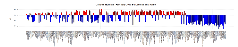
These are just the stations deemed ‘Normals” by Environment Canada. The temperature is the departure from the 1971-2000 average in Celsius. I’m using monthly summary.
This graphs data is sorted by Longitude (West to East) and By Name. Click for bigger.

This graphs data is sorted by Latitude (North to South) and By Name. Click for bigger.

Learn something new….Lethbridge…Nfld!!! I looked at the name and said no way, he’s got it wrong, checked out maps and sure enough, one exists in Newfoundland!!
I never knew that either.
My wife is from Nfld, so I know a lot of towns there…yours truly though born in Quesnel BC…but an Albertan now…
Warm Pacific Ocean keeping Siberia Sea of Okhotsk from freezing. The Jet Stream moves north or south based on the heat available in the land and/or water; but drives from west to east. The Pacific warmth moves from west to east.
The heat transfer to space is maximum over the “North Pole” [rotational]. Not enough heat and a further south Jet Stream in the west pushes Arctic cold south over the eastern US and Canada.