La Nina is coming …
One of the strongest El Niños on record has been dominating the tropical Pacific Ocean for the past year. But beneath the surface, a deep pool of cool water has been sliding slowly eastward for the past couple of months. This massive, slow-motion wave is a favorable sign that La Niña—the cool phase of the ENSO climate pattern—might develop.
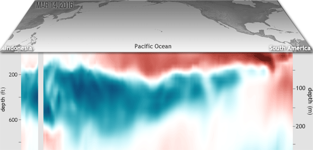
This animated gif shows where temperatures in the top 300 meters (~1,000 feet) of the Pacific Ocean at the equator were warmer or cooler than average during 5-day periods centered on three dates this spring: March 14, April 13, and May 3.
As the weeks pass, the layer of warm water at the surface contracts to the central Pacific and becomes very shallow, a sign that the current El Niño is on its way out. By the final frame of the animation, the cold pool is just breaching the surface of the eastern Pacific off South America. (You can see these cool-water breakthroughs in our map of April 2016 surface temperatures.)

Reblogged this on Climate Collections.
Reblogged this on pdx transport.
It’s already starting


UNISYS
DMI
It will probably be a strong one like in 1999-2001,
