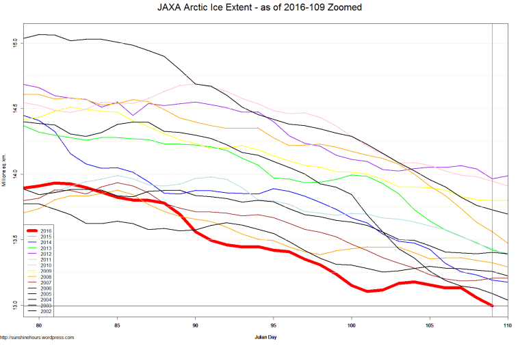
They are predicting a record low sea ice for 2016 because ” Comparably little new ice formed during the past winter.”
Even though I am now using JAXA (because the NSIDC sensor problems) and Jaxa sea ice data only goes back to 2002, I’d like to point out two things.
- April 20th 2012 sea ice extent was highest ever (in history of Jaxa) as you can see below (the purple line) It wasn’t low ice in April that caused a record in 2012.
2. The Great Arctic Cyclone 2012 Caused the Record Low. You can read my blog post here.
The opening paragraph:
Great Arctic Cyclone 2012 Caused the Record Low
Update: Watch a NASA simulation of the cyclone breaking up the ice.
The Great Arctic Cyclone of 2012 hit on Aug 5 and passed over the North Pole on Aug 6.
“An unusually strong storm formed off the coast of Alaska on Aug. 5, then moved over the central Arctic. The Moderate Resolution Imaging Spectroradiometer (MODIS) on NASA’s Aqua satellite took the images that make up the mosaic during various passes over the North Pole on Aug. 6, when the storm was swirling over the middle of the Arctic Ocean. According to a NASA statement,there have only been about eight storms of similar strength during the month of August in the last 34 years of satellite records.
Using Jaxa data, note that from July 20 all the way to Aug 5, Arctic Sea Ice area was higher than in 2007. The peak day was Aug 5th, when 2012 was 229,062 sq km more than 2007.
Once the Cyclone hit, the ice broke and melted. It isn’t the apocalypse in the Arctic. It was weather!

Yes, the claims of ice losses are premature.
https://rclutz.wordpress.com/2016/04/22/premature-reports-of-ice-death/