Arctic Sea Ice – April Trends – Last 10 Years Looking Ok!

I saw the following article at the NSIDC site about the trend for April Sea Ice Extent in the Arctic.

NSIDC_Arctic_April_2013

And I wondered what it would look like if I just graphed the last 10 years. And I thought … looking ok.

Arctic Sea Ice Extent for April Since 2004

And then I though … how about the last 20 years with a loess curve? Don’t you think the NSIDC articles words are misleading?

Arctic Sea Ice Extent for April Since 1994

Arctic Sea Ice 2013 is only 4th lowest so far

Arctic Sea Ice Extent 2013 is only 4th lowest so far using the mean up to this day in each year.

And the anomaly is half the 2006 anomaly.

We are saved!

Year Anomaly (sq km)
2006 -916,781
2005 -744,955
2007 -743,831
2013 -484,217
2010 -446,517
2012 -445,151
2009 -401,894
2004 -347,932
2008 -307,371
1996 -212,097
2000 -121,103
2002 -54,227
2001 -16,150
2003 14,480
1995 17,785
1991 52,640
1999 66,556
1997 96,180
1984 139,216
1992 184,595
1989 256,508
1994 271,011
1998 344,667
1981 375,843
1985 380,320
1990 399,046
1993 467,706
1988 479,840
1986 513,926
1987 598,476
1980 644,064
1983 693,561
1982 744,653
1979 950,301

(daily data from here)

Arctic_Sea_Ice_Extent_Zoomed_2013_Day_102_1981-2010

Arctic Sea Ice Extent Only 1.4% Lower Than 1981-2010 Mean

Did you know that the Arctic Sea Ice Extent is only 1.4% lower than the 1981 – 2010 mean?

NSIDC data says that on March 19 (day 78) Arctic Sea Ice Extent was 15.09 million sq km. The mean for 1981-2010 for day 78 is 15.30 million sq km.

Wow. Only 1.4% below normal. Has that made the news?


Arctic_Sea_Ice_Extent_Anomaly_Pct

Arctic Data from here.

University of Washington Team Beclowns Themselves Over 2012 Arctic Cyclone

A “team” of “University” of Washington “scientists” have beclowned themselves trying to claim the massive 2012 Arctic Cycle did not speed up the ice melt.

Their argument comes down to: “By September, most of the ice that melted would have melted with or without the cyclone.”

If you take two ice cubes and smash one into tiny pieces, which one melts first?  The smashed one of course.

But the ice BESIDE the smashed ice would also melt quicker because the smashed ice would have provided support and cold/insulation if it had not been smashed.

For those of us old enough to remember fridge freezers that ice up and did not defrost themselves, we remember smashing as much ice with knives or screwdrivers to expose ice further back so it could melt sooner.


The UW team should be ashamed of themselves.

Has the AMO Peaked? May-Oct says No and Nov-Apr says Yes.

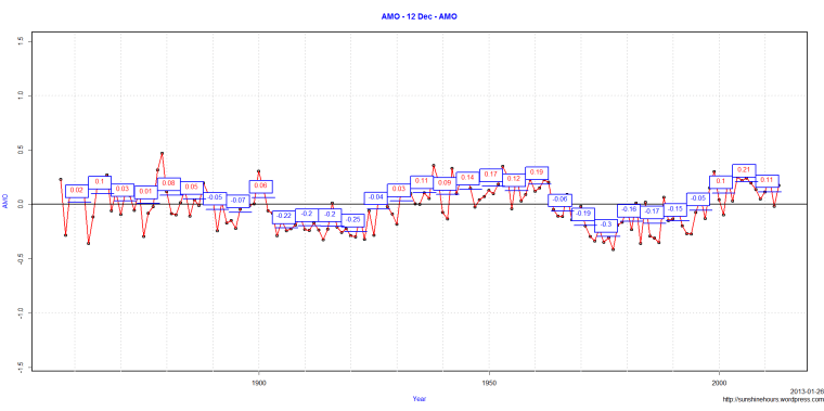
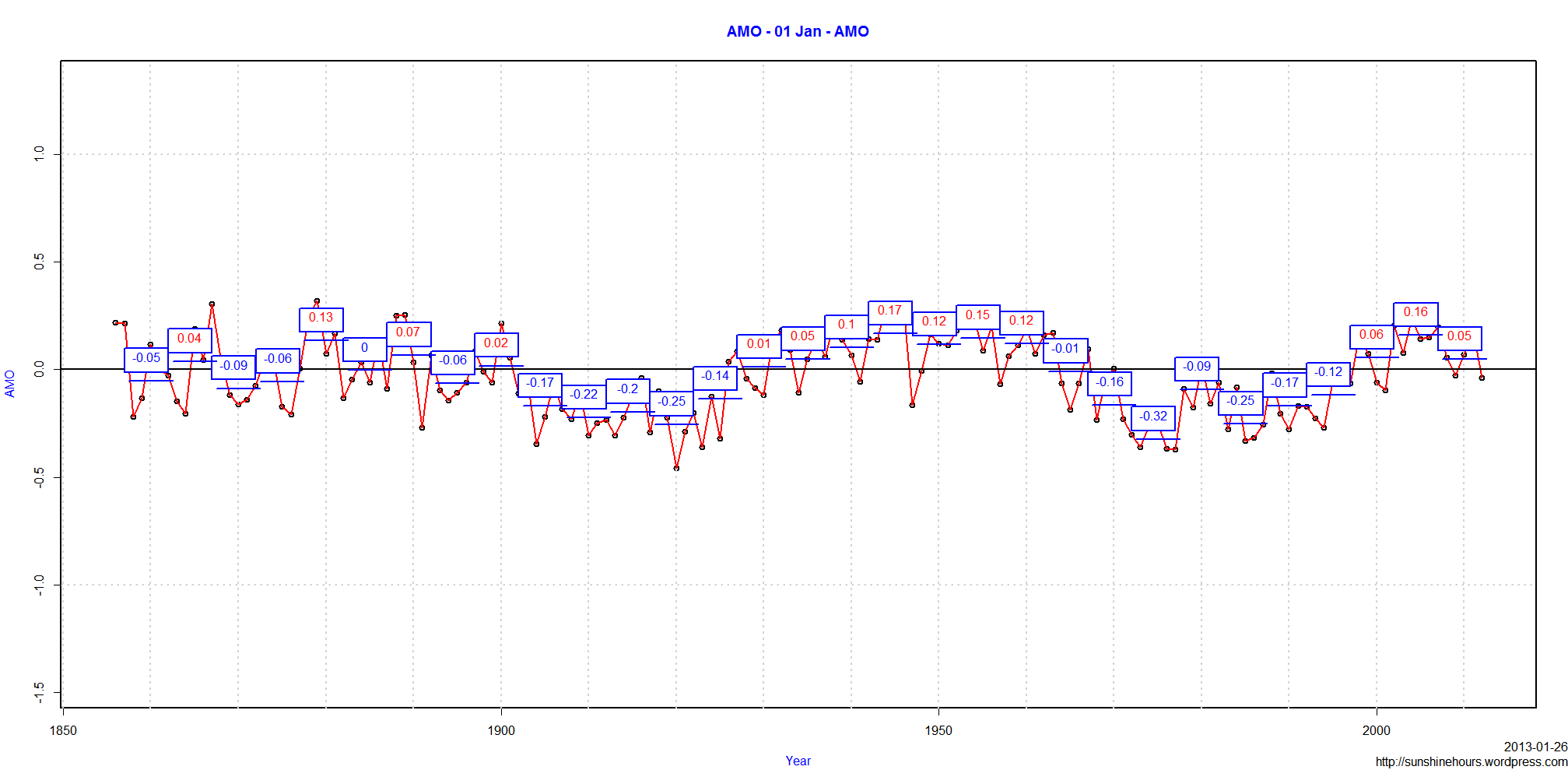
Has the AMO Peaked and started its drop towards negative?  The answer is yes for winter months and no for summer months.

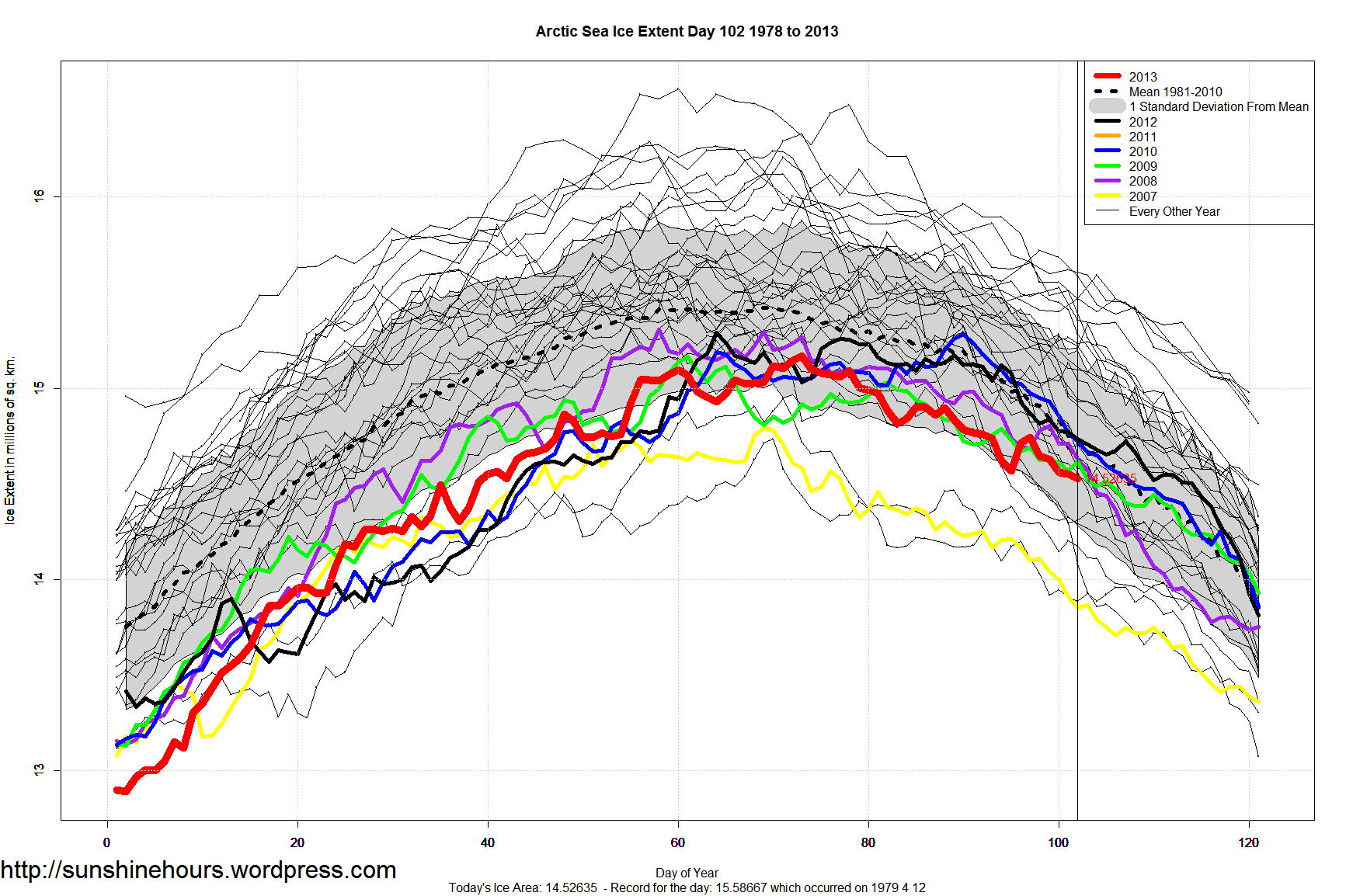
Maybe thats why winter Arctic Ice is doing fine and summer Arctic Ice is not doing fine.

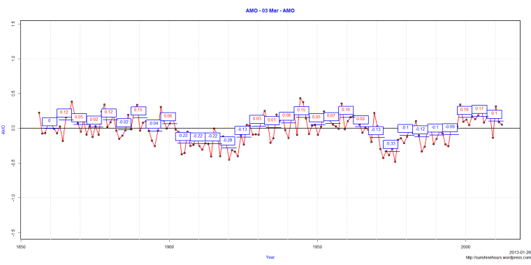
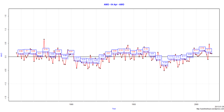
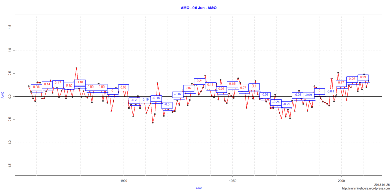
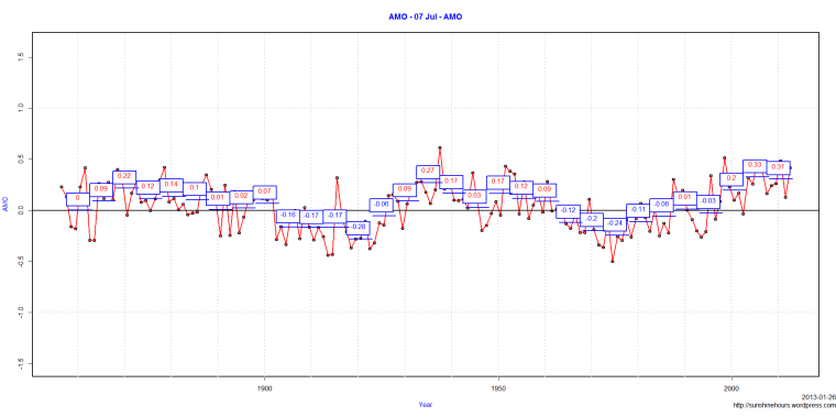
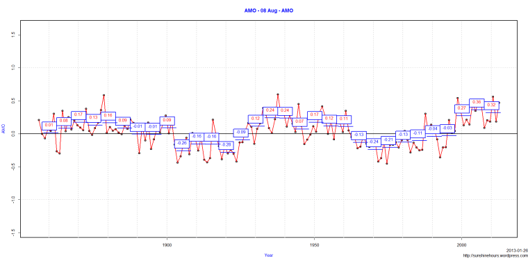
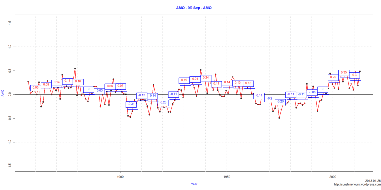
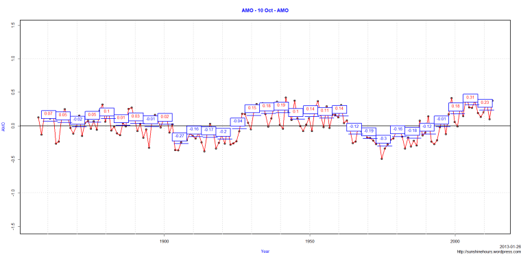
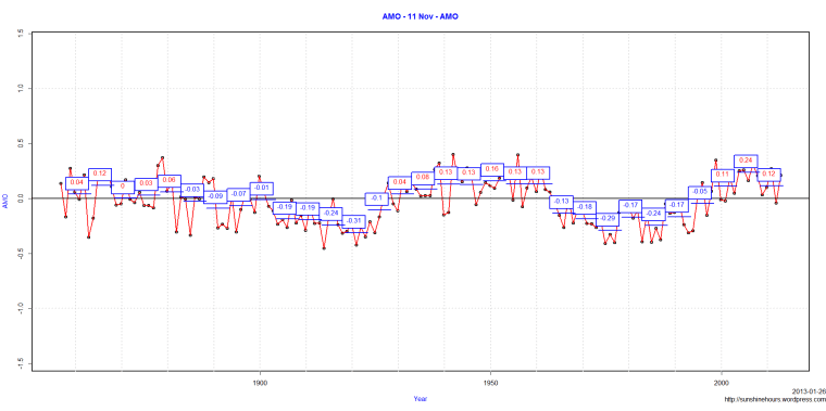
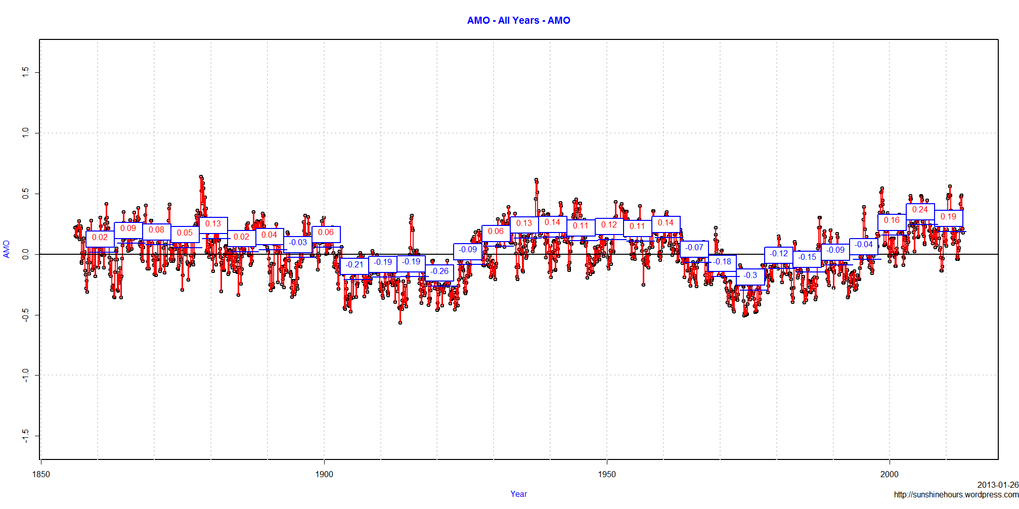
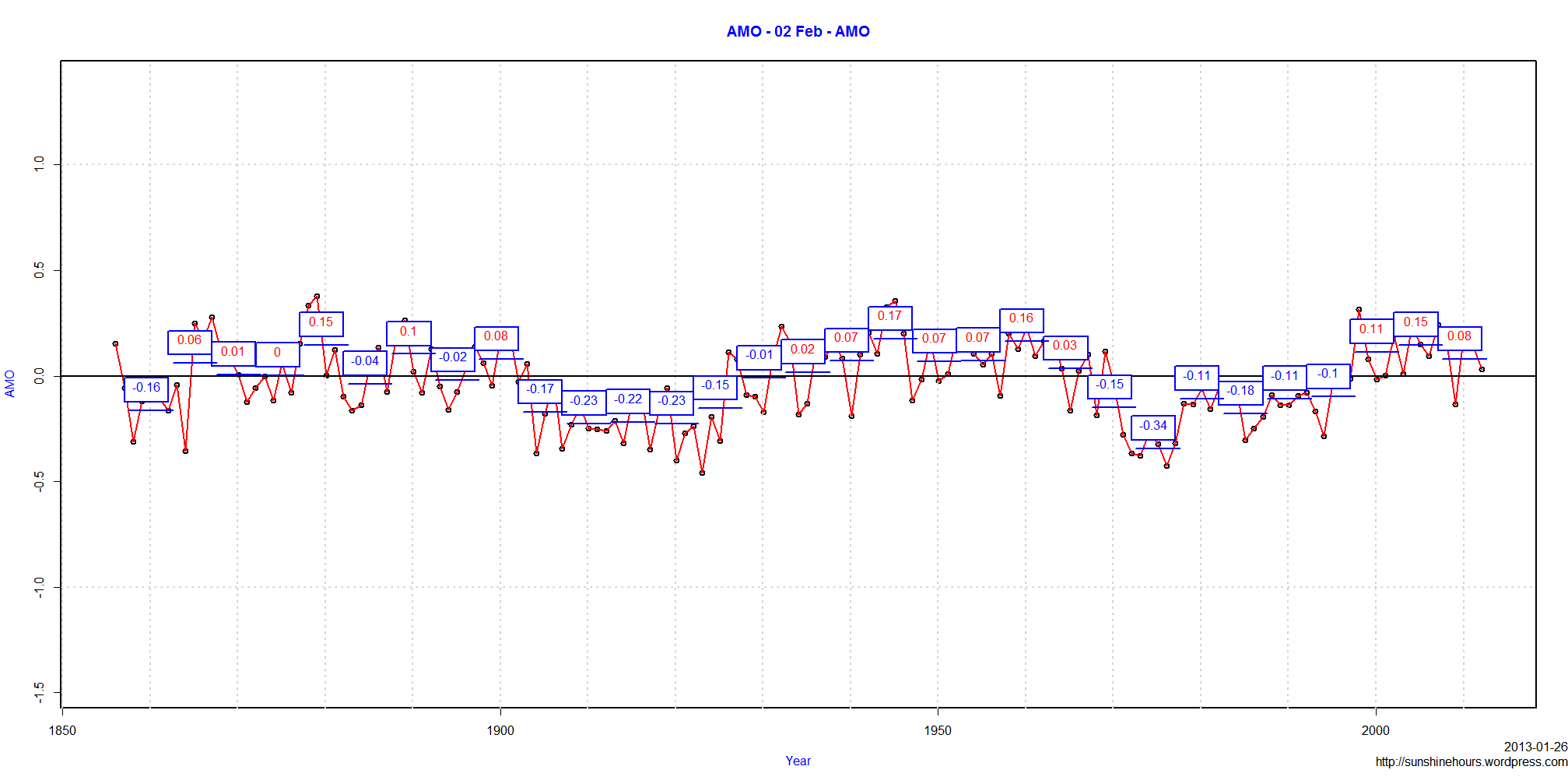
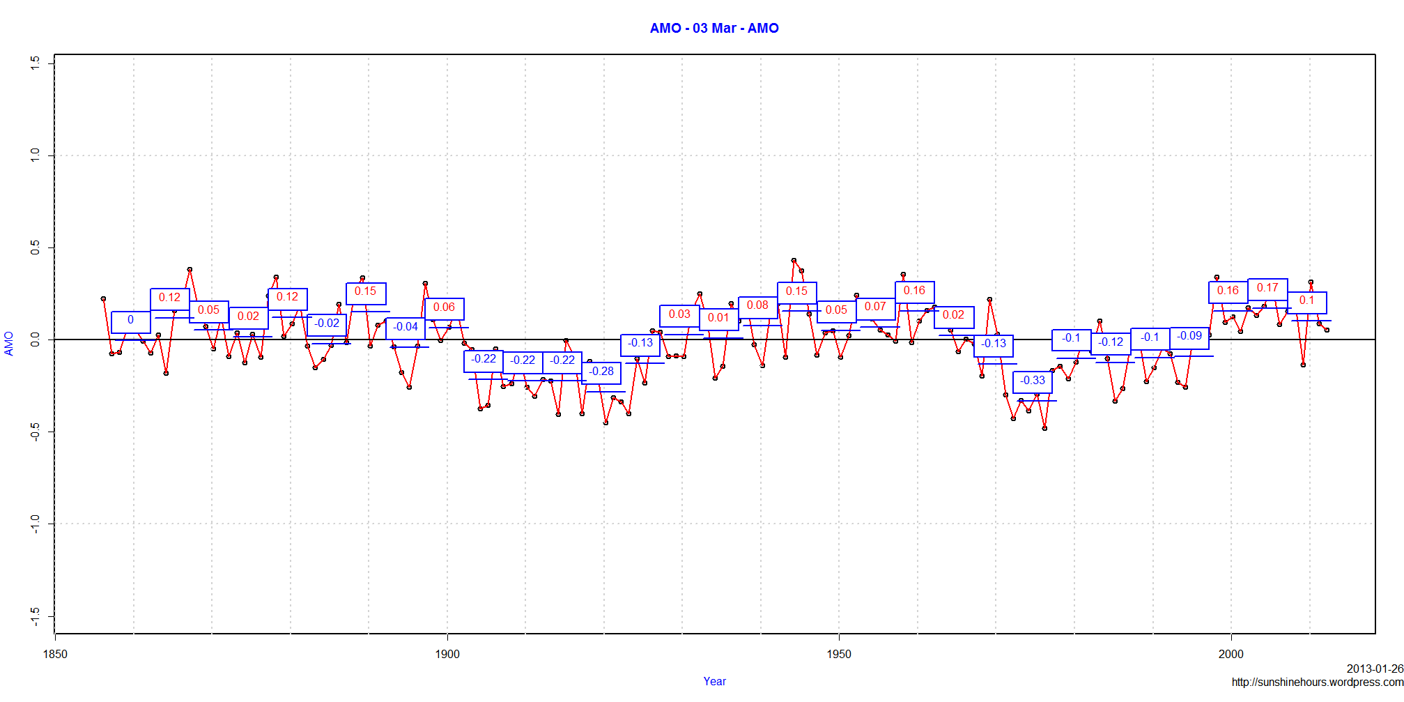
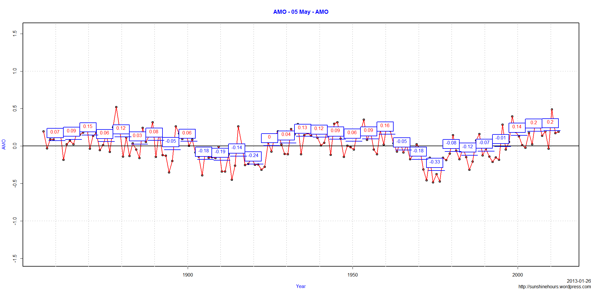
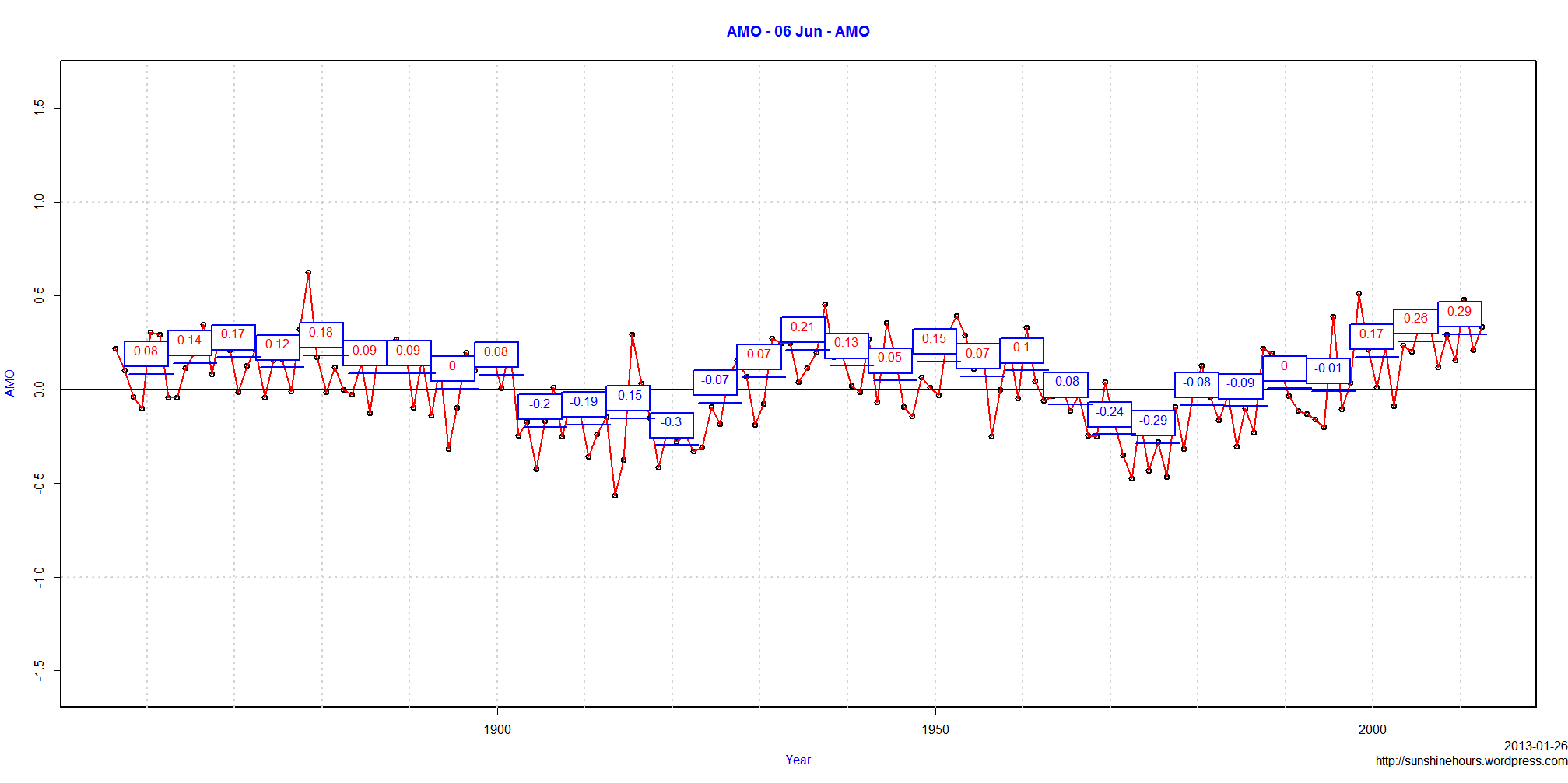
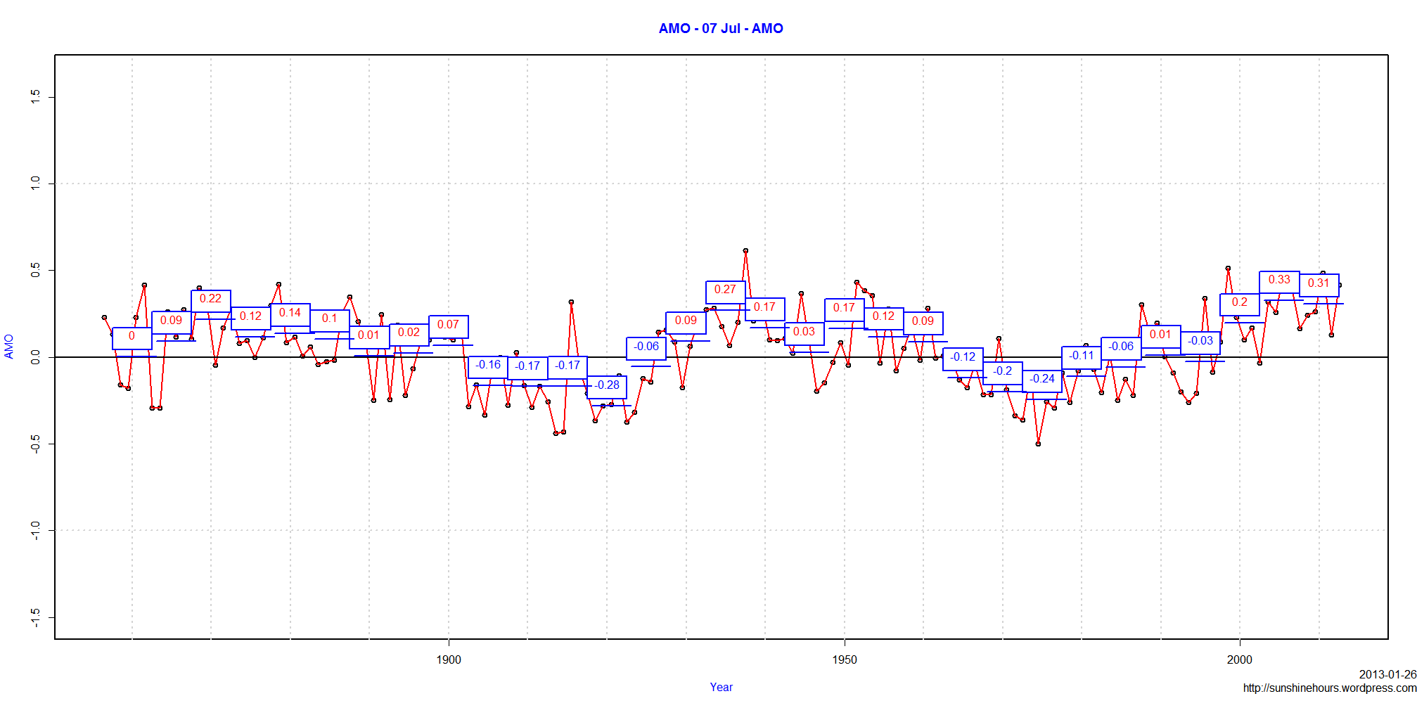
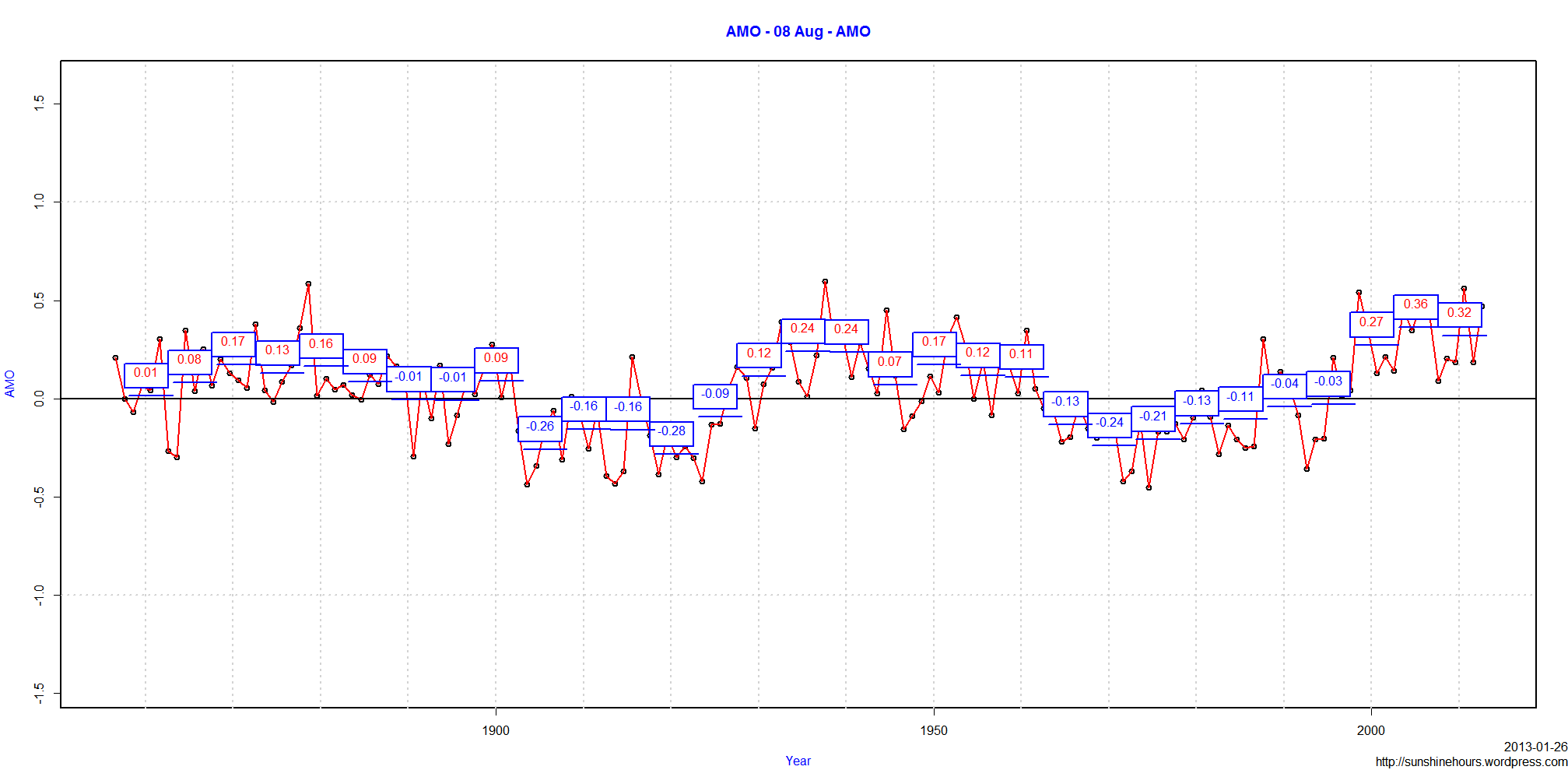
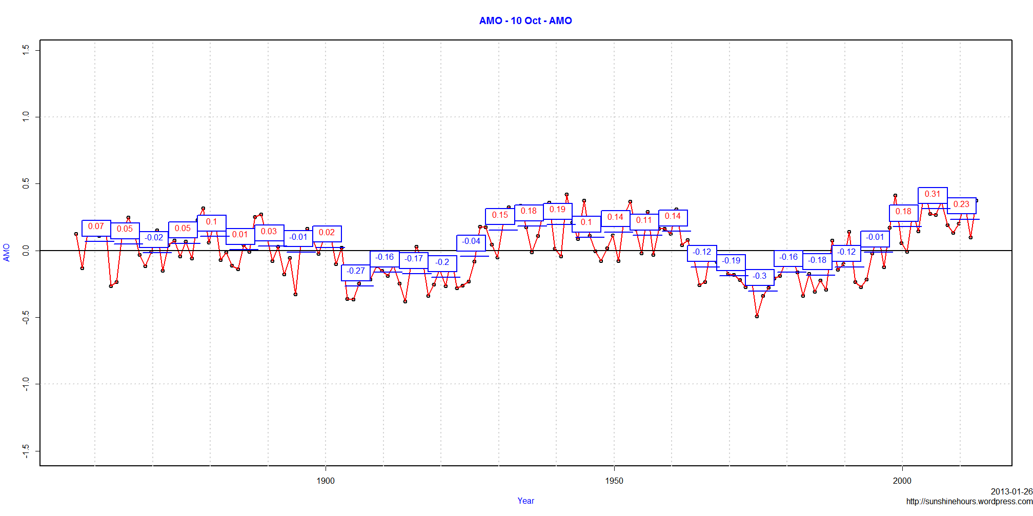
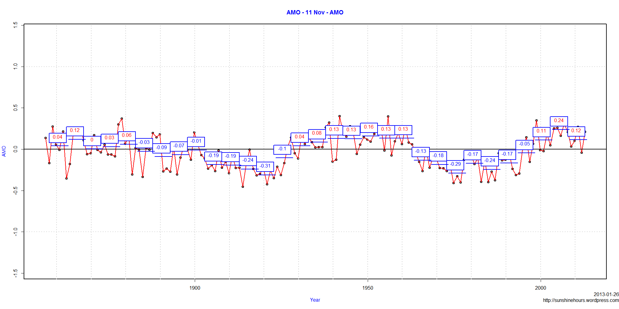
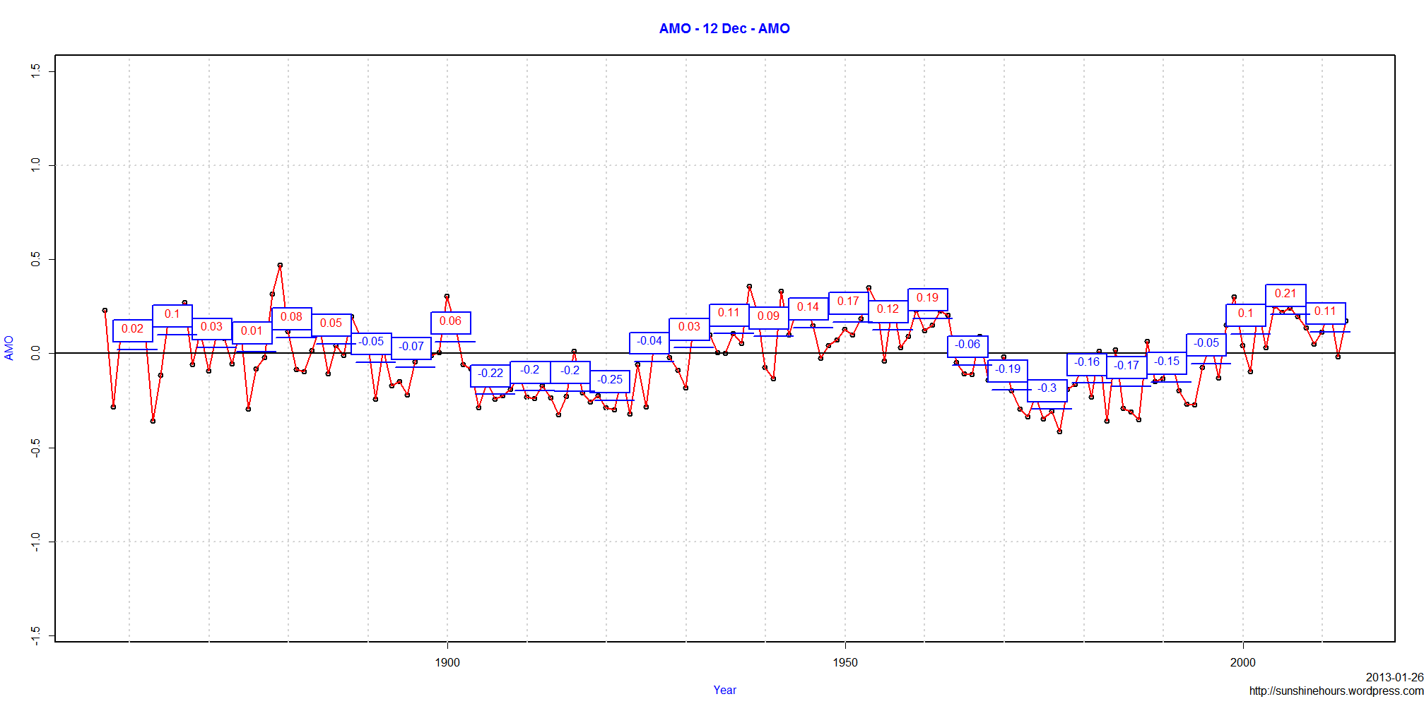
I have included a graph for the AMO for all years that we have data, and then the AMO broken down for each individual month.

The blue boxes in the graphs contain 5 years averages, the blue line underneath is the 5 year period. Red values = above 0 and blue values = below 0.

The All Years AMO has dropped a little over the last 5 years compared to the previous 5 years, but the value is still higher than the 1950 peak of the AMO (but not as high as the short peak around 1878).

It is also interesting that the 1950 peak was in the middle of a 35-40 year period above zero and the current peak is only 15 years long. The AMO may still have decades left above zero, but the winter months look like it was a shorter peak.

May to October 5 year values are still higher than the previous peak around 1950.

November to April have dropped and are now lower than the previous peak around 1950.

Click on any graph to make it bigger.

AMO - All Years - AMO
AMO - 01 Jan - AMO
AMO - 02 Feb - AMO AMO - 03 Mar - AMO AMO - 04 Apr - AMO AMO - 05 May - AMO AMO - 06 Jun - AMO AMO - 07 Jul - AMO AMO - 08 Aug - AMO AMO - 09 Sep - AMO AMO - 10 Oct - AMO AMO - 11 Nov - AMO AMO - 12 Dec - AMO

Arctic Sea Ice – 2nd Most New Ice

2013 Arctic Sea Ice has increased by .96 million sq km since Jan 1 according to NOAA.

That is the 2nd largest increase ever for this day 17.

Year Start Day Last Day Starting Ice Extent Ice Extent Today New Ice
1993 1 17 14.026 15.056 1.03
2013 1 17 12.897 13.86 0.963
1986 1 17 13.997 14.926 0.929
2003 1 17 13.615 14.538 0.923
2009 1 17 13.138 14.039 0.901
1985 2 18 14.025 14.839 0.814
1991 1 17 13.607 14.401 0.794
2002 1 17 13.544 14.323 0.779
1997 1 17 13.607 14.38 0.773
2000 1 17 13.403 14.174 0.771
2001 1 17 13.435 14.193 0.758
1983 1 17 14.233 14.989 0.756
1989 1 17 14.228 14.982 0.754
1980 1 17 14.191 14.941 0.75
1982 2 18 14.46 15.186 0.726
1981 1 17 14.259 14.95 0.691
1998 1 17 13.996 14.683 0.687
1994 1 17 14.068 14.751 0.683
2008 1 17 13.155 13.83 0.675
2005 1 17 13.119 13.769 0.65
2010 1 17 13.133 13.757 0.624
1987 2 18 14.285 14.902 0.617
1999 1 17 13.789 14.375 0.586
2007 1 17 13.076 13.66 0.584
2004 1 17 13.486 14.054 0.568
1995 1 17 14.111 14.65 0.539
2011 2 17 12.895 13.419 0.524
1992 1 17 14.038 14.541 0.503
1990 1 17 14.255 14.682 0.427
1996 1 17 13.766 14.18 0.414
2006 1 17 13.116 13.41 0.294
2012 1 17 13.369 13.569 0.2
1984 2 18 14.087 14.249 0.162
1988 14 17 14.828 14.978 0.15

Arctic Sea Ice Not As Bad As They Claimed??? DMI

Among the ice charts I peek at every day is the one from DMI (Danish Meteorological Institute).

Today there was a new Sea Ice Extent Chart with this text at the bottom:

The plot above replaces an earlier sea ice extent plot, that was based on data with the coastal zones masked out.

That implied that the previous sea ice extent estimates were underestimated.

The new plot displays absolute sea ice extent estimates.


Arctic Sea Ice Extent supposedly bottomed out around 2.5 million sq km according to the old chart posted by DMI for months.


Imagine my surprise when today the Sea Ice Extent bottomed out at 4 million sq km. and the chart looked like

Maybe that explains why Arctic-roos site isn’t showing any charts.

Arctic Sea Ice Extent Up 105.9% From Minimum

Arctic Sea Ice Extent has risen 105.9% from minimum.

The table below is for each year 36 days after minimum (which is where 2012 is).

Year Min_Day Minimum_Extent Day Extent Extent_Change Extent_Change_Pct
2012 260 3.36855 296 6.9346 3.56605 105.9
2008 262 4.55469 298 8.6348 4.08011 89.6
2005 265 5.31832 301 8.99287 3.67455 69.1
2010 262 4.59918 298 7.7708 3.17162 69
1990 264 6.0191 300 9.80574 3.78664 62.9
1999 255 5.68009 291 8.79531 3.11522 54.8
2007 257 4.1607 293 6.24682 2.08612 50.1
2004 263 5.77608 299 8.66593 2.88985 50
2002 256 5.62456 292 8.41471 2.79015 49.6
1991 259 6.26027 295 9.23626 2.97599 47.5
2003 260 5.97198 296 8.76889 2.79691 46.8
1998 260 6.29922 296 9.06504 2.76582 43.9
2000 255 5.9442 291 8.55331 2.60911 43.9
1989 265 6.88931 301 9.90128 3.01197 43.7
1979 264 6.89236 300 9.81273 2.92037 42.4
2006 257 5.74877 293 8.08785 2.33908 40.7
1993 249 6.15699 285 8.62008 2.46309 40
2009 255 5.05488 291 7.04661 1.99173 39.4
1984 260 6.39916 296 8.88718 2.48802 38.9
2011 251 4.30207 287 5.93733 1.63526 38
1982 256 7.15423 292 9.79515 2.64092 36.9
2001 262 6.56774 298 8.77267 2.20493 33.6
1988 255 7.04905 291 9.3216 2.27255 32.2
1981 253 6.88784 289 8.96254 2.0747 30.1
1985 250 6.4799 286 8.41305 1.93315 29.8
1986 249 7.12351 285 9.21502 2.09151 29.4
1992 251 7.16324 287 9.23786 2.07462 29
1996 254 7.15283 290 9.19238 2.03955 28.5
1983 251 7.19145 287 9.15526 1.96381 27.3
1995 252 5.98945 288 7.57822 1.58877 26.5
1987 245 6.89159 281 8.62349 1.7319 25.1
1994 248 6.92645 284 8.33525 1.4088 20.3
1980 249 7.52476 285 8.93393 1.40917 18.7
1997 246 6.61353 282 7.66599 1.05246 15.9

In terms of total area 36 days after minimum, 2012 is 4th.

Year Min_Day Minimum_Extent Day Extent Extent_Change Extent_Change_Pct
2008 262 4.55469 298 8.6348 4.08011 89.6
1990 264 6.0191 300 9.80574 3.78664 62.9
2005 265 5.31832 301 8.99287 3.67455 69.1
2012 260 3.36855 296 6.9346 3.56605 105.9
2010 262 4.59918 298 7.7708 3.17162 69
1999 255 5.68009 291 8.79531 3.11522 54.8
1989 265 6.88931 301 9.90128 3.01197 43.7
1991 259 6.26027 295 9.23626 2.97599 47.5
1979 264 6.89236 300 9.81273 2.92037 42.4
2004 263 5.77608 299 8.66593 2.88985 50
2003 260 5.97198 296 8.76889 2.79691 46.8
2002 256 5.62456 292 8.41471 2.79015 49.6
1998 260 6.29922 296 9.06504 2.76582 43.9
1982 256 7.15423 292 9.79515 2.64092 36.9
2000 255 5.9442 291 8.55331 2.60911 43.9
1984 260 6.39916 296 8.88718 2.48802 38.9
1993 249 6.15699 285 8.62008 2.46309 40
2006 257 5.74877 293 8.08785 2.33908 40.7
1988 255 7.04905 291 9.3216 2.27255 32.2
2001 262 6.56774 298 8.77267 2.20493 33.6
1986 249 7.12351 285 9.21502 2.09151 29.4
2007 257 4.1607 293 6.24682 2.08612 50.1
1981 253 6.88784 289 8.96254 2.0747 30.1
1992 251 7.16324 287 9.23786 2.07462 29
1996 254 7.15283 290 9.19238 2.03955 28.5
2009 255 5.05488 291 7.04661 1.99173 39.4
1983 251 7.19145 287 9.15526 1.96381 27.3
1985 250 6.4799 286 8.41305 1.93315 29.8
1987 245 6.89159 281 8.62349 1.7319 25.1
2011 251 4.30207 287 5.93733 1.63526 38
1995 252 5.98945 288 7.57822 1.58877 26.5
1980 249 7.52476 285 8.93393 1.40917 18.7
1994 248 6.92645 284 8.33525 1.4088 20.3
1997 246 6.61353 282 7.66599 1.05246 15.9

Arctic Sea Ice Extent 5th Biggest Increase

Three days ago I did a post about it being the 8th largest refreeze at the same days as 2012.

The most recent data is from day 294 (34 days past minimum), so the post is about the most new ice from minimum to the 34th day after minimum.

2012 has moved up from 8th to 5th in terms of area, and of course it is even further ahead in percentage change at 92.7%.

Arctic Sea Ice has increased by 500,000 sq km in just 3 days.

Year Minimum_Extent ExtentDay Extent Extent_Change Extent_Change_Pct
2008 4.55469 296 8.34631 3.79162 83.2
1990 6.0191 298 9.62753 3.60843 59.9
2005 5.31832 299 8.74216 3.42384 64.4
2010 4.59918 296 7.73029 3.13111 68.1
2012 3.36855 294 6.49108 3.12253 92.7
1999 5.68009 289 8.66543 2.98534 52.6
1989 6.88931 299 9.81185 2.92254 42.4
1991 6.26027 293 9.13597 2.8757 45.9
1979 6.89236 298 9.67205 2.77969 40.3
2004 5.77608 297 8.41616 2.64008 45.7
2002 5.62456 290 8.22117 2.59661 46.2
1982 7.15423 290 9.73903 2.5848 36.1
1998 6.29922 294 8.87962 2.5804 41
2003 5.97198 294 8.53999 2.56801 43
2000 5.9442 289 8.4217 2.4775 41.7
1988 7.04905 289 9.25929 2.21024 31.4
1984 6.39916 294 8.60637 2.20721 34.5
1993 6.15699 283 8.33967 2.18268 35.5
2006 5.74877 291 7.88317 2.1344 37.1
2001 6.56774 296 8.56063 1.99289 30.3
1981 6.88784 287 8.85254 1.9647 28.5
1986 7.12351 283 9.05756 1.93405 27.2
1996 7.15283 288 9.08053 1.9277 27
1992 7.16324 285 9.05854 1.8953 26.5
1983 7.19145 285 9.07326 1.88181 26.2
2009 5.05488 289 6.82818 1.7733 35.1
2007 4.1607 291 5.88829 1.72759 41.5
1987 6.89159 279 8.54745 1.65586 24
1985 6.4799 284 8.10411 1.62421 25.1
2011 4.30207 285 5.70884 1.40677 32.7
1980 7.52476 283 8.74495 1.22019 16.2
1994 6.92645 282 8.14096 1.21451 17.5
1995 5.98945 286 6.96936 0.97991 16.4
1997 6.61353 280 7.39169 0.77816 11.8