Tag: weather
NOAA vs USCRN July 2012
The USCRN is a new ‘state of the art’ United States Climate Reference Network.
The USCRN “consists of 114 stations developed, deployed, managed, and maintained by the National Oceanic and Atmospheric Administration (NOAA) in the continental United States for the express purpose of detecting the national signal of climate change.”
This is the monthly Mean from both NOAA and USCRN for July 2012 for the 48 continental states.
9 states show USCRN stations warmer than NOAA (bold) and 39 show NOAA warmer than USCRN.
| State | NOAA | USCRN | NOAA_minus_USCRN |
| Alabama | 81.7 | 80.83 | 0.87 |
| Arizona | 80.3 | 81.41 | -1.11 |
| Arkansas | 84.1 | 84.2 | -0.1 |
| California | 75 | 72.32 | 2.68 |
| Colorado | 71.2 | 71.29 | -0.09 |
| Florida | 82.2 | 81.56 | 0.64 |
| Georgia | 82.3 | 82 | 0.3 |
| Idaho | 70.2 | 71.96 | -1.76 |
| Illinois | 81.7 | 77.54 | 4.16 |
| Indiana | 80.2 | 81.68 | -1.48 |
| Iowa | 79.4 | 80.06 | -0.66 |
| Kansas | 84.3 | 84.02 | 0.28 |
| Kentucky | 80.7 | 80.24 | 0.46 |
| Louisiana | 82.1 | 82.04 | 0.06 |
| Maine | 68 | 66.74 | 1.26 |
| Michigan | 73.3 | 68.9 | 4.4 |
| Minnesota | 74.4 | 70.52 | 3.88 |
| Mississippi | 81.8 | 80.15 | 1.65 |
| Missouri | 83.7 | 82.04 | 1.66 |
| Montana | 71.4 | 67.89 | 3.51 |
| Nebraska | 80 | 79.47 | 0.53 |
| Nevada | 73.6 | 73.52 | 0.08 |
| New Hampshire | 69.6 | 70.61 | -1.01 |
| New Mexico | 74.6 | 72.91 | 1.69 |
| New York | 71.7 | 71.15 | 0.55 |
| North Carolina | 80.5 | 76.52 | 3.98 |
| North Dakota | 73.8 | 73.16 | 0.64 |
| Ohio | 77.6 | 76.28 | 1.32 |
| Oklahoma | 85.5 | 84.78 | 0.72 |
| Oregon | 67.4 | 66.42 | 0.98 |
| Rhode Island | 73.1 | 71.87 | 1.23 |
| South Carolina | 82.7 | 81.86 | 0.84 |
| South Dakota | 78.8 | 77.86 | 0.94 |
| Tennessee | 80.4 | 75.92 | 4.48 |
| Texas | 83.4 | 82.76 | 0.64 |
| Utah | 74.2 | 74.03 | 0.17 |
| Virginia | 79 | 80.24 | -1.24 |
| Washington | 66.6 | 63.44 | 3.16 |
| West Virginia | 75.5 | 68 | 7.5 |
| Wisconsin | 74.7 | 76.64 | -1.94 |
| Wyoming | 71.5 | 69.98 | 1.52 |
The Recent Heat Wave In Canada
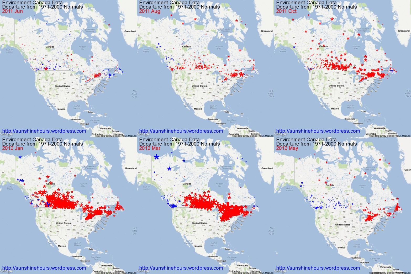
Environment Canada designates some stations with data that is the Departure from Normals 1971-2000.
This animated gif is the subset of stations with “Normals” mapped. The size of the blue (colder than Normal) or red (warmer than Normal) is related to the magnitude.
As you can see the recent heat wave that is making headlines is like a red wave that engulfs most of Canada and then retreats back to the north and eastern Canada.
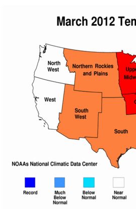
What does NOAA mean by “Near Normal”?
Yes I know that most of the USA was warm in March of 2012. But what does the NOAA mean by “Near Normal” in the North West and West regions?
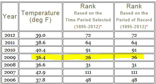
In the North West, March 2012 was the 72nd warmest March out of 118. 118 is the warmest. It was 7F colder than 1934 which was the warmest March. 7F colder. Wow.
The North West has been cold recently. March 2011 was the 64th warmest, 2010 was the 91st warmest, 2009 was the 26th warmest and 2008 was the 31st warmest.
92 Marches were warmer than 2009. 2009 was 9.6F colder than March of 1934.
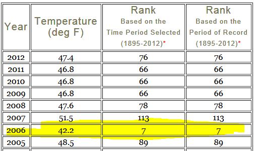
In the West region, March 2012 was 76th warmest. It was 7.6F colder than 1934, again the warmest March.
But take a look at 2006. 7th warmest. 111 were warmer. The last 5 years have been quite cold.
1934 sure turns up a lot as the year with the warmest month.
Wait until we took a look at April. I’ll give you a hint. 5th and 6th warmest out of 118 in the last 4 years. 112 and 113 warmer Aprils.
Archangel Trends using BEST data – very slight cooling since 1920
I was reading a post at WUWT concerning GISS adjustments to Arctic stations and I thought I would see what BEST data shows for the main station in question. It shows a very slight cooling since 1920. Six of the months are warming and six are cooling. 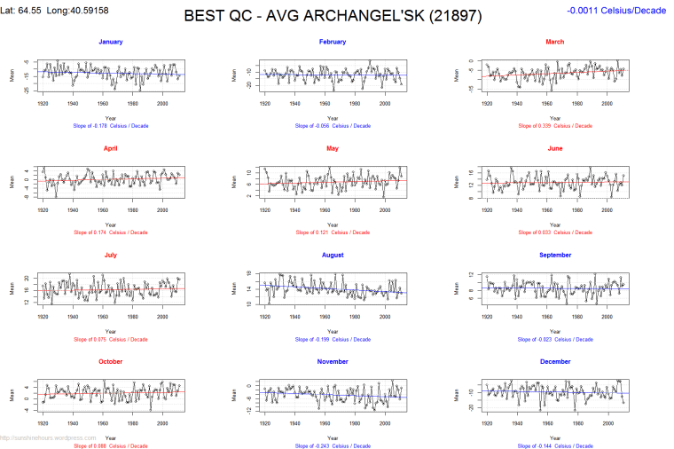
Sunshine and Temperature in Alberta and BC Canada
I recently scraped the Environment Canada website for climate data in BC and Alberta. I’ve been learning R and I thought I would graph the mean of the sunshine hours and temperature for each month. Do remember this is only stations with BOTH bright sunshine and temperature records for the month.
In Alberta the number of stations reporting sunshine peaked in the 1980s around 24.
Alberta Stations with Temp + Sunshine July
In BC the number peaked around 64 in 1988.
