USHCN Only 51 Stations Have A Full Set Of Monthly Data For 1961-1990

UPDATE: Published. Not in moderation.

Over at WUWT I have a couple of comments in moderation in the argument about US climate data. This one of them (slightly clarified).


Zeke is quoted: “The way that NCDC, GISS, Hadley, myself, Nick Stokes, Chad, Tamino, Jeff Id/Roman M, and even Anthony Watts (in Fall et al) all calculate temperatures is by taking station data, translating it into anomalies by subtracting the long-term average for each month from each station (e.g. the 1961-1990 mean)”

To create a 1961-1990 baseline, you would have 360 monthly values.

The USHCN monthly data has error flags. The E flag means the data for that month is Estimated. There is not enough daily data to created a monthly value.

There are ONLY 51 stations that had 360 values without an E flag from 1961-1990.

That means only 51 out of 1218 stations have relatively complete data to use as a baseline.


WY MORAN 5 WNW USH00486440 is one of the 51

WY NEWCASTLE USH00486660 is one that failed. 61 months of the 360 had an E flag. (Admittedly my comment had a typo over at WUWT).

And I just looked at the E flag. There lots of other flags.


Here is the other comment:


Anthony, you should double check Zeke’s work.

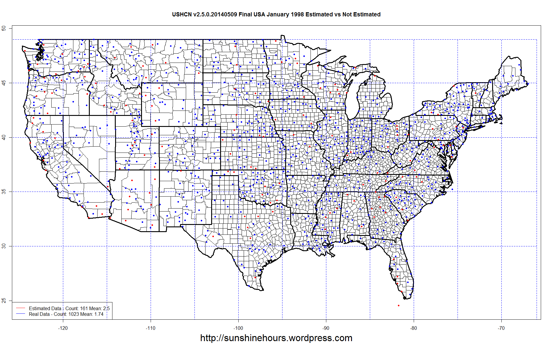
Using USHCN Final Tavg dated v2.5.0.20140622

July 2012 – 880 Stations have data without the E for Estimated flag.

There are 1218 stations.

27% of the July 2012 Stations are missing data.

July of 1895 has 472 station reporting Real (non-Estimated) data

61%. of the July 1895 stations are missing data.

Now remember, I am only look at the monthly records. Monthly records avoid the E flag if there are enough daily data. It doesn’t mean there is data for every day.


NOAA USA – Maximum Temperatures Top 3 for July are 1936, 1934 and 1901

According to the NOAA, July 1936 is now back on top as the warmest month in USA history for average temperature.

The new NOAA page allows checking of maximum Temperature.

The top 3 are 1936, 1934 and 1901. 1931, 1954 and 1930 are in the top 10 as well.

NOAA_July_1936_MAX_data


NOAA_July_1936_MAX


Sea Ice Update June 25 2014 – Antarctic Sea Ice Extent is 1,444,000 sq km Above ‘Normal’

A quick update for sea ice extent for day 175 of 2014

  • Global Sea Ice Extent is 589,000 sq km above the 1981-2010 mean. That is ranked 5 for the day.
  • Antarctic Sea Ice Extent is 1,444,000 sq km above the 1981-2010 mean. That is ranked 1 for the day.
  • Arctic Sea Ice Extent is -856,000 sq km below the 1981-2010 mean. That is ranked 32 for the day.

Global_Sea_Ice_Extent_Zoomed_2014_Day_175_1981-2010

Antarctic_Sea_Ice_Extent_Zoomed_2014_Day_175_1981-2010

Arctic_Sea_Ice_Extent_Zoomed_2014_Day_175_1981-2010

Sea Ice Update June 23 2014 – Antarctic Climbing Even Higher – Global Still Above 1 SD

A quick update for sea ice extent for day 173 of 2014

  • Global Sea Ice Extent is 696,000 sq km above the 1981-2010 mean. That is ranked 4 for the day.
  • Antarctic Sea Ice Extent is 1,499,000 sq km above the 1981-2010 mean. That is ranked 1 for the day. That is the 106th daily record for 2014.
  • Arctic Sea Ice Extent is -803,000 sq km below the 1981-2010 mean. That is ranked 32 for the day.

Global_Sea_Ice_Extent_Zoomed_2014_Day_173_1981-2010

Antarctic_Sea_Ice_Extent_Zoomed_2014_Day_173_1981-2010

Arctic_Sea_Ice_Extent_Zoomed_2014_Day_173_1981-2010

USHCN 2.5 – OMG … The Old Data Changes Every Day

Yesterday I did a post about old USHCN changing from month to month.

So I thought why compare data sets from one day to the next. Certainly they can’t be changing old data every day … could they?

So I compared the June 21 2014 TAvg Final dataset (ushcn.tavg.latest.FLs.52i.tar.gz) from here  to the same file from June 22 2014

And just to keep it manageable. I compared only the data from Jan 1998.

And here we are … the data even for 1998 changes from day to day.

Consider the “SANDPOINT EXP STN” station. On June 21 the monthly average temperature for Jan 1998 was -1.33C.  On June 22 2014 it was -0.89C for an increase in temperature of .44C.

These are all the records where the temperature changed or the Error Flag changed.

11 got warmer. 4 got colder. And even the non-Estimated data changes. OMG. How can you actually analyze the data if the past temperature changes every day.

Year STATE NAME Station LATITUDE LONGITUDE ELEVATION Month DATA1 E1 Version1 DATA2 E2 Version2 dif
1998 FL ARCADIA USH00080228 27.2181 -81.8739 9.1 1 17.61 E v2.5.0.20140621 17.63 E v2.5.0.20140622 0.02
1998 ID PRIEST RIVER EXP STN USH00107386 48.3514 -116.8358 725.4 1 -2.77 v2.5.0.20140621 -2.78 v2.5.0.20140622 -0.01
1998 ID SANDPOINT EXP STN USH00108137 48.2928 -116.5578 640.1 1 -1.33 a v2.5.0.20140621 -0.89 a v2.5.0.20140622 0.44
1998 MI NEWBERRY 3S USH00205816 46.3133 -85.5106 259.1 1 -9 v2.5.0.20140621 -8.86 v2.5.0.20140622 0.14
1998 NC ELIZABETH CITY USH00312719 36.3097 -76.205 2.4 1 7.93 a v2.5.0.20140621 7.94 a v2.5.0.20140622 0.01
1998 NY SARATOGA SPRINGS 4 SW USH00307484 43.0331 -73.8167 94.5 1 -3.19 v2.5.0.20140621 -3.17 v2.5.0.20140622 0.02
1998 TN CROSSVILLE ED & RESEARCH USH00402202 36.0147 -85.1311 551.7 1 5.14 a v2.5.0.20140621 5.17 a v2.5.0.20140622 0.03
1998 VA BREMO BLUFF USH00440993 37.7092 -78.2886 68.6 1 6.25 d v2.5.0.20140621 6.24 d v2.5.0.20140622 -0.01
1998 VA FARMVILLE 2 N USH00442941 37.3264 -78.3864 137.2 1 4.94 a v2.5.0.20140621 4.93 a v2.5.0.20140622 -0.01
1998 VA HOPEWELL USH00444101 37.2992 -77.2772 12.2 1 7.27 b v2.5.0.20140621 7.29 b v2.5.0.20140622 0.02
1998 VA NORFOLK INTL AP USH00446139 36.9033 -76.1922 9.1 1 8.18 v2.5.0.20140621 8.33 v2.5.0.20140622 0.15
1998 VA WILLIAMSBURG 2 N USH00449151 37.3017 -76.7039 21.3 1 6.96 a v2.5.0.20140621 6.98 a v2.5.0.20140622 0.02
1998 WA NORTHPORT USH00455946 48.9114 -117.8069 423.7 1 -2.13 v2.5.0.20140621 -2.14 v2.5.0.20140622 -0.01
1998 WI MANITOWOC USH00475017 44.0869 -87.6522 178 1 -4.12 E v2.5.0.20140621 -4.11 E v2.5.0.20140622 0.01
1998 WI WATERTOWN USH00478919 43.1742 -88.7364 251.5 1 -3.94 v2.5.0.20140621 -3.93 v2.5.0.20140622 0.01

USHCN 2.5 – 1998 Keeps Getting Warmer

This is another post on USHCN warming. You can read more here.

USHCN puts out a monthly dataset every day. For the last month or so I was using the data I downloaded on on 20140509. I have been using the Final tavg data.

Today I downloaded the 20140621 version from here: ftp://ftp.ncdc.noaa.gov/pub/data/ushcn/v2.5

I thought … why not map both sets and compare the average temperature for the USA in Jan 1998 between the two sets of data.

In the legend I placed the count of Real versus Estimated and the average.

I was shocked. They are still warming 1998!

On May 9 the mean of the Estimated data was 2.5C and the mean of the Real Data was 1.74 … which is a .76C spread.

On June 21 the mean of the Estimated data was 2.72C and the mean of the Real Data was 1.7 … which is a 1.02C spread.

OMG. They keep changing the data. And they are still warming 1998!!!


USHCN v2.5.0.20140509 Final USA January 1998 Estimated vs Not Estimated

USHCN v2.5.0.20140621 Final USA January 1998 Estimated vs Not Estimated

MASIE June 20 2014 – Arctic Sea Ice Up Over Last 7 Days

June 20 2014  MASIE Update – According to MASIE Arctic Sea Ice is up 3,100 over the last 7 days mostly due to the 61,521 rise in last day.

While some the arctic is melting according to MASIE, some of it is growing over the last 7 days: Barents, Kara, Laptev, East Siberian and Greenland Sea.

Pretty amazing for this time in the melt season. DMI does have Arctic temperatures below normal.

Region Start End Last 82 Last 28 Last 14 Last 7 Last 3 Last 1
Hudson Bay 1,260,903 1,119,258 -141,645 -111,224 -50,148 -48,416 -21,491 -22,406
Baffin Bay Gulf of St. Lawrence 1,688,530 879,085 -809,446 -300,514 -144,901 -37,741 6,122 37,975
Bering Sea 697,324 45,557 -651,766 -77,664 -60,843 -23,404 -7,241 -5,930
Beaufort Sea 1,070,445 1,015,139 -55,306 -50,201 -28,723 -18,103 -24,470 -121
Chukchi Sea 966,006 817,475 -148,531 -99,447 -51,996 -15,302 -29,339 -7,937
Sea of Okhotsk 853,240 14,729 -838,511 -65,213 -50,635 -11,649 -1,544 -1,544
Canadian Archipelago 853,214 782,198 -71,016 -41,704 -19,202 -1,516 -3,042 0
Central Arctic 3,221,921 3,242,295 20,374 -4,399 1,693 -949 -1,364 0
Baltic Sea 15,337 0 -15,337 0 0 0 0 0
Yellow Sea 0 0 0 0 0 0 0 0
Barents Sea 645,917 265,967 -379,950 -191,521 -72,654 2,693 -9,850 -16,013
Kara Sea 933,859 862,375 -71,485 -26,479 -3,285 20,582 22,369 12,303
Laptev Sea 897,845 713,573 -184,272 -143,282 -14,040 22,417 9,362 12,002
East Siberian Sea 1,087,137 1,042,709 -44,429 10,158 11,674 33,542 37,355 8,236
Greenland Sea 603,416 690,530 87,114 -41,792 61,702 80,945 9,953 44,956
Northern Hemisphere (Total) 14,805,115 11,492,415 -3,312,699 -1,142,945 -420,973 3,100 -13,180 61,521
NH (Average Loss per Day) -39,912 -40,819 -30,070 443 -4,393 61,521

MASIE Arctic Ice Extent as of 2014-170

MASIE June 19 2014 – Arctic Slow Melting Last 7 Days

June 19 2014  MASIE Update – Only –15,526 sq km per day melt over last 7 days.

Region Start End Last81 Last28 Last14 Last7 Last3 Last1
Baffin Bay Gulf of St. Lawrence 1,688,530 841,110 -847,421 -347,865 -183,069 -62,930 -26,068 4,125
Chukchi Sea 966,006 825,412 -140,594 -91,509 -51,561 -39,216 -21,402 -21,402
Hudson Bay 1,260,903 1,141,664 -119,240 -90,837 -47,369 -28,483 8,623 12,286
Bering Sea 697,324 51,488 -645,836 -60,502 -49,693 -25,542 -1,311 -1,311
Beaufort Sea 1,070,445 1,015,260 -55,185 -50,080 -33,773 -19,909 -15,150 -25,184
Sea of Okhotsk 853,240 16,272 -836,967 -65,666 -53,107 -5,770 -5,020 0
Canadian Archipelago 853,214 782,198 -71,016 -39,930 -15,649 -4,458 379 868
Baltic Sea 15,337 0 -15,337 0 0 0 0 0
Yellow Sea 0 0 0 0 0 0 0 0
Central Arctic 3,221,921 3,242,295 20,374 -4,399 2,599 597 -1,364 -1,364
Kara Sea 933,859 850,072 -83,788 -37,031 -16,379 9,134 10,066 10,066
Barents Sea 645,917 281,980 -363,937 -149,818 -66,439 10,541 6,163 6,163
Laptev Sea 897,845 701,571 -196,274 -151,947 -38,056 16,358 -2,639 -2,639
Greenland Sea 603,416 645,574 42,158 -47,289 43,468 19,062 -22,097 -37,779
East Siberian Sea 1,087,137 1,034,473 -52,664 3,971 3,746 21,938 29,119 29,119
Northern Hemisphere (Total) 14,805,115 11,430,895 -3,374,220 -1,132,547 -504,895 -108,679 -40,701 -27,053
NH (Average Loss per Day) -41,149 -40,448 -36,064 -15,526 -13,567 -27,053

MASIE Arctic Ice Extent as of 2014-169