USA NOAA First 5 Months (Jan-May) Were Only Ranked 56 out of 120

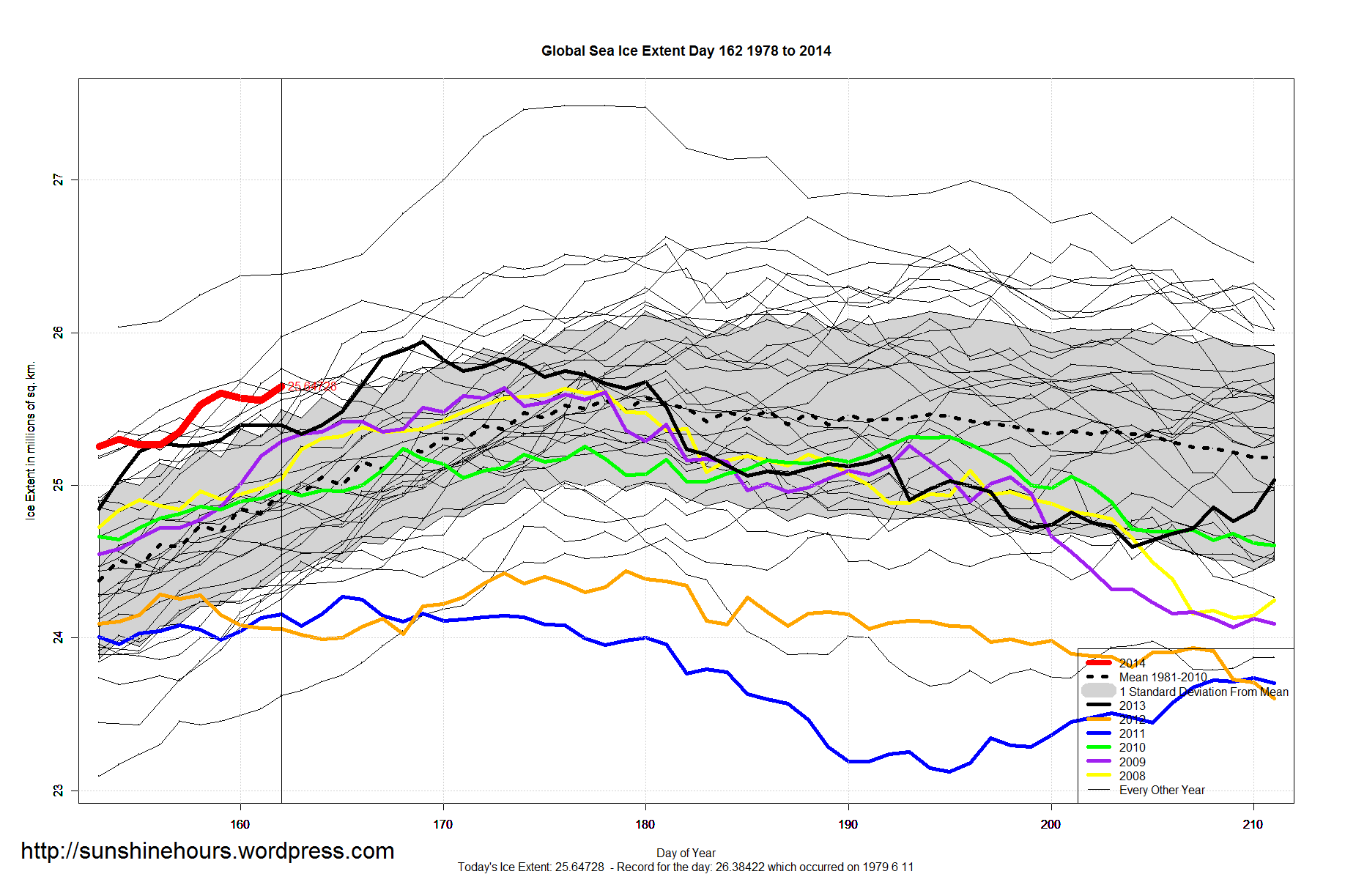
According to the NOAA the first 5 months (Jan-May) 2014 was ranked 56th out of 120 (120 = warmest) .

The cooling trend for Jan-May dates back to 1990. 2012 was the hot aberration.

NOAA_Jan_May_2014_Temperature_TREND_1990


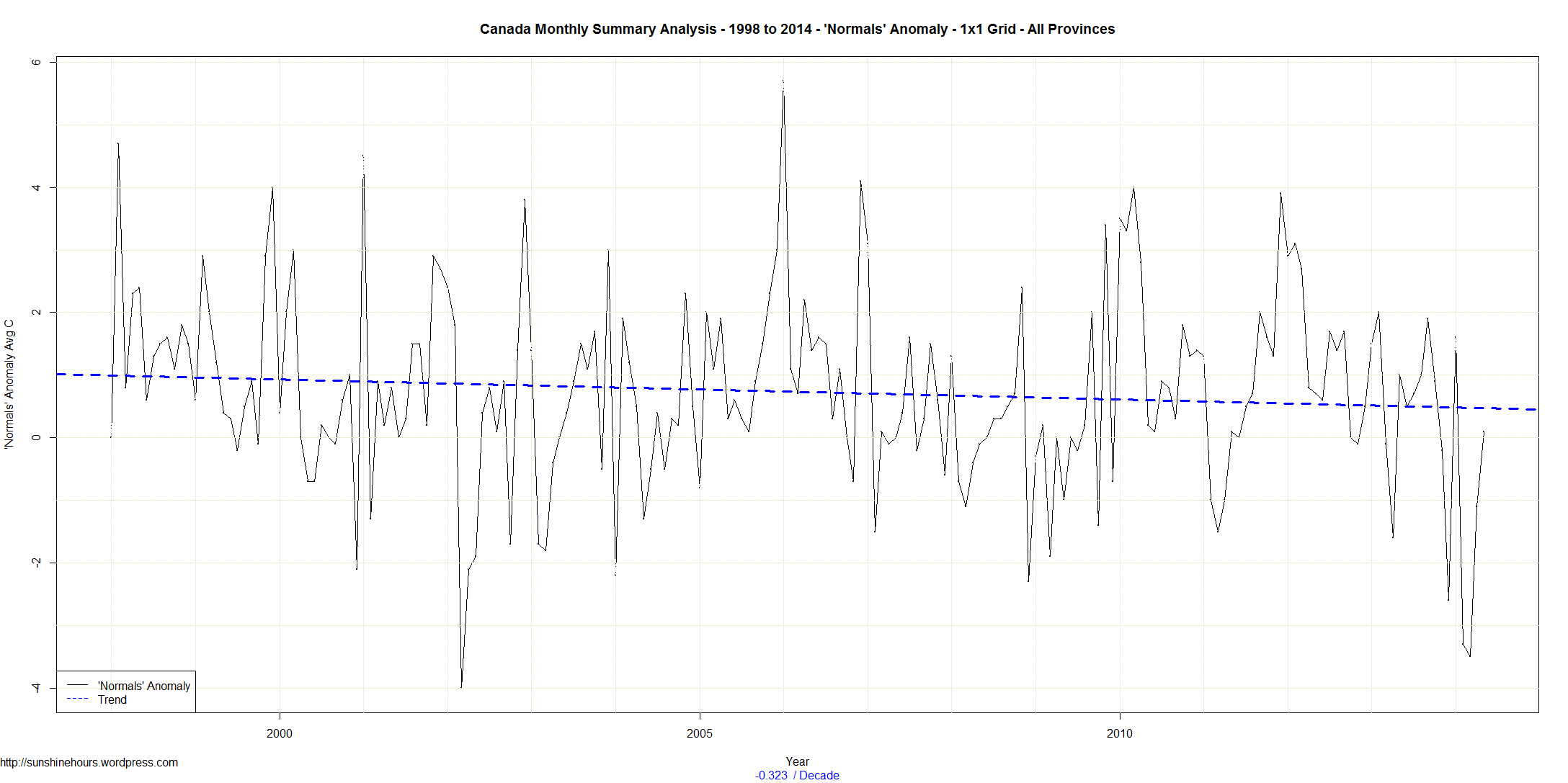
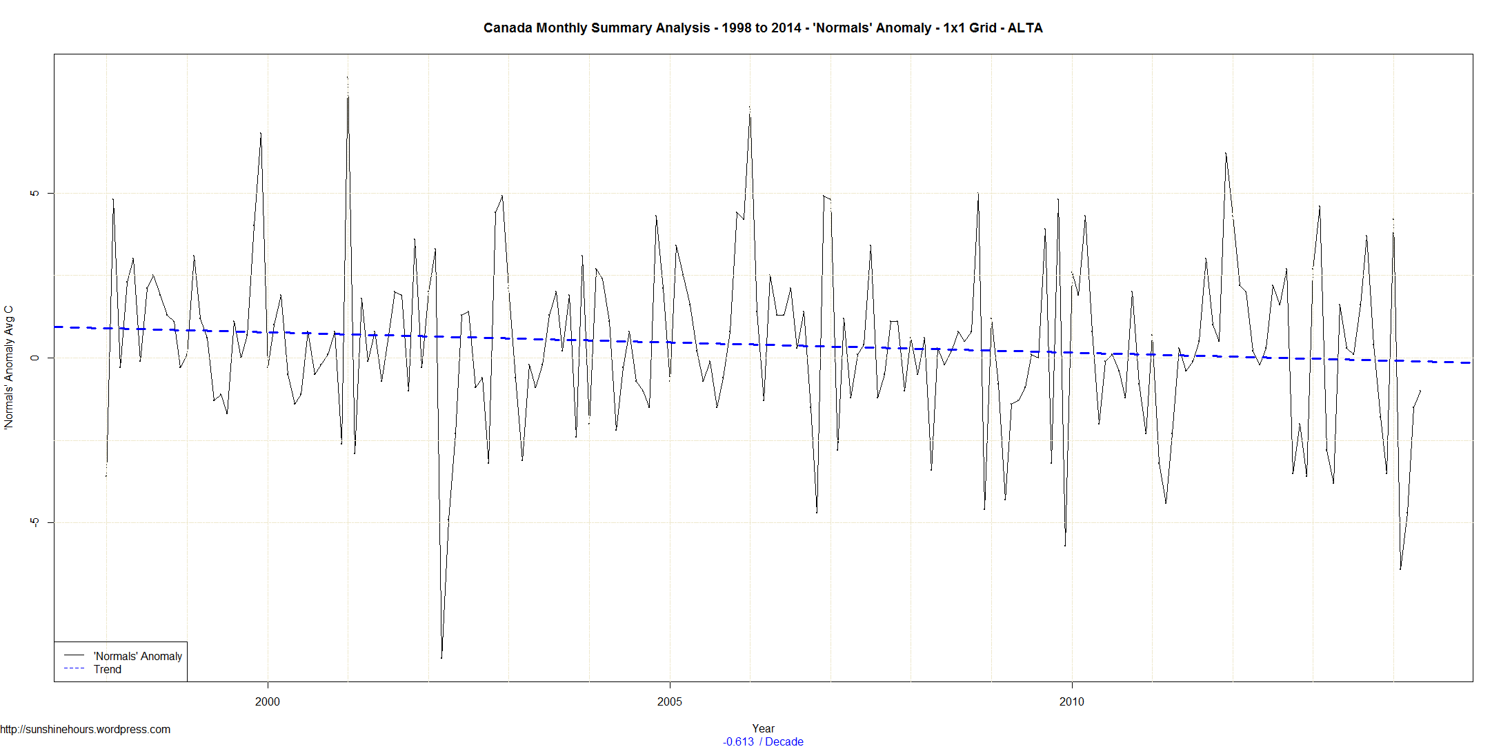
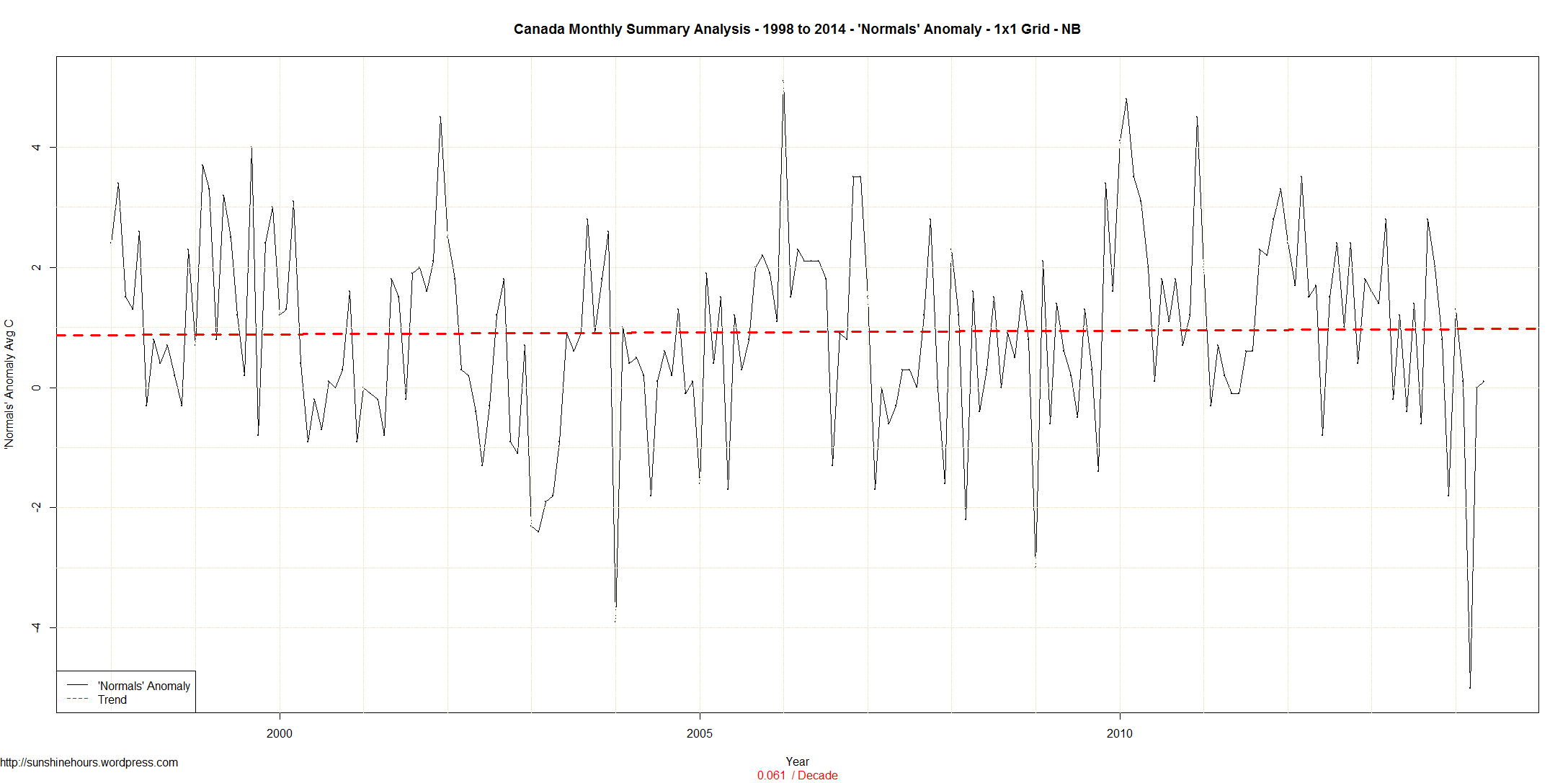
These are the anomalies from the Jan-May average. It has been a cold start to the year for the East while warmer in the south west.


cag_[ Statewide Avg Temp Anomalies (average between Jan 2014 and May 2014) ]


Sea Ice Update June 12 2014 – Arctic Sea Ice Within One Standard Deviation of ‘Normal’

Arctic Sea Ice Within One Standard Deviation of ‘Normal’ and 600,000 sq km higher than 2010.

A quick update for sea ice extent for day 162 of 2014:

  • Global Sea Ice Extent is 711,000 sq km above the 1981-2010 mean. That is ranked 5 for the day.
  • Antarctic Sea Ice Extent is 1,168,000 sq km above the 1981-2010 mean. That is ranked 1 for the day.
  • Arctic Sea Ice Extent is -457,000 sq km below the 1981-2010 mean. That is ranked 30 for the day.

NOAA Data here and here here. Graphs below. Click for bigger.


Arctic_Sea_Ice_Extent_Zoomed_2014_Day_162_1981-2010

Global_Sea_Ice_Extent_Zoomed_2014_Day_162_1981-2010

Antarctic_Sea_Ice_Extent_Zoomed_2014_Day_162_1981-2010

Sea Ice Update June 11 2014 – Antarctic Sea Ice Extent is 1,157,000 sq km Above ‘Normal’

A quick update for sea ice extent for day 161 of 2014:

  • Global Sea Ice Extent is 678,000 sq km above the 1981-2010 mean. That is ranked 5 for the day.
  • Antarctic Sea Ice Extent is 1,157,000 sq km above the 1981-2010 mean. That is ranked 1 for the day.
  • Arctic Sea Ice Extent is -480,000 sq km below the 1981-2010 mean. That is ranked 30 for the day.

NOAA Data here and here here. Graphs below. Click for bigger.


Global_Sea_Ice_Extent_Zoomed_2014_Day_161_1981-2010

Antarctic_Sea_Ice_Extent_Zoomed_2014_Day_161_1981-2010

Arctic_Sea_Ice_Extent_Zoomed_2014_Day_161_1981-2010

USHCN 2.5 – Estimated Warming By Year and Month

This is the 3rd or 4th post on USHCN warming. You can read more here.

Today I have taken the Final data from 1895 to 2013 and am comparing the average for each month Estimated to Real in Celsius.

As you can see, in all cases the Estimated data is warmer. What a shock! (Not really).

Month Estimated Real Estimated minus Real
Jan 0.17 -1.02 1.19
Feb 1.95 0.8 1.15
Mar 6.39 5.42 0.97
Apr 11.53 10.85 0.68
May 16.45 15.96 0.49
Jun 21.05 20.54 0.51
Jul 23.61 23.21 0.4
Aug 22.86 22.37 0.49
Sep 18.94 18.42 0.52
Oct 12.97 12.45 0.52
Nov 6.5 5.82 0.68
Dec 1.5 0.54 0.96

The next table is just the difference for each year and month. If Estimated is larger than Real, then the color will be red, otherwise blue. If the difference is more than 1 or -1, then bold will emphasize.

Red means the Estimated data is hotter than the non-estimated for that year and month.

Blue is much rarer than red. And bold blue is very rare indeed.

Year Jan Feb Mar Apr May Jun Jul Aug Sep Oct Nov Dec
1895 0.12 -0.29 0.04 0.06 -0.38 0.22 -0.2 -0.21 -0.31 0.09 0.26 0.67
1896 0.78 0.9 1.08 1.21 0.84 0.54 0.15 0.29 0.39 0.43 0.4 0.1
1897 -0.24 0.48 0.66 0.23 -0.14 -0.07 0.03 -0.11 0.44 -0.11 -0.19 0.9
1898 -0.27 0.16 -0.24 0.16 -0.41 -0.05 0 0.23 0.03 -0.82 -0.93 -0.35
1899 0.17 -0.03 0.39 -0.37 -0.33 -0.54 -0.28 -0.23 0.14 -0.47 0.18 0.26
1900 0.89 0.97 1.35 0.56 -0.35 -0.05 -0.11 -0.22 -0.34 -0.74 -0.23 0.48
1901 1.57 1.74 1.16 0.43 0.24 -0.07 0.16 0.26 -0.22 -0.05 0.17 0.42
1902 1.25 0.74 -0.3 0.37 0.25 -0.1 0.09 0.18 0.01 -0.25 -0.6 0.87
1903 0.26 0.58 0.17 0.68 -0.27 0.45 0.44 0.69 0.38 0.6 0.53 1.15
1904 1.16 2.62 2.11 1.34 0.67 0.92 0.39 0.92 0.34 0.29 0.7 0.72
1905 0.84 1.04 0.67 -0.12 -0.07 -0.3 0.04 0.21 0.02 -0.99 -0.05 -0.09
1906 -0.59 0.19 -0.05 0.05 -0.43 0.06 0.39 0.45 0.22 0.03 -0.27 0.69
1907 -0.59 0.76 -0.06 0.16 -0.05 -0.34 -0.56 -0.55 -0.55 0.05 -0.19 -0.5
1908 0.6 1.07 1.28 0.34 -0.38 -0.63 -0.21 -0.25 -0.4 -0.58 -0.04 -0.34
1909 -0.14 -0.15 0.05 -0.62 -1.05 -0.93 -0.42 -0.63 -0.62 -0.2 -0.81 -0.28
1910 0.45 0.01 -0.19 -0.14 0.18 0.26 0.16 0.04 0.41 -0.71 -0.45 0.86
1911 -0.29 -0.92 0.64 0.23 -0.73 -0.1 -0.48 -0.48 -0.59 -1.21 -0.93 -1.71
1912 0.52 0.77 -0.39 -1.29 -0.63 -0.29 -0.21 0.11 -0.8 -1.14 -0.63 -1.13
1913 -0.49 0.49 0.01 -0.33 0.13 0.1 0.35 0.11 0.11 0.05 -0.23 -0.81
1914 0.3 -0.11 0.46 -0.09 -0.24 0.02 0.35 0.51 0.03 -0.25 0.53 0.33
1915 0.32 0.27 0.92 -0.3 -0.32 -0.81 -0.32 0.4 -0.19 -0.2 0.21 0.87
1916 -0.95 1.24 1.12 0.31 -0.29 0.34 -0.04 0.15 0.11 -0.18 -0.07 -0.13
1917 -0.26 1.36 0.54 0.37 0.52 0.84 0.39 0.42 0.96 1.34 0.75 2.01
1918 1.65 1.44 0.36 0.67 -0.23 0.64 0.4 0.48 0.65 0.89 0.26 0.45
1919 0.38 0.68 0.44 0.33 0.26 0.25 0.06 0.27 0.32 0.06 -0.15 0.11
1920 -0.23 0 0.04 -0.12 0.35 0.35 0.36 -0.03 -0.31 -0.24 -1.1 -1.55
1921 -0.48 0.04 -0.06 -0.22 0.16 0.07 0.24 0.49 1.12 0.9 1.9 1.18
1922 0.74 1.04 0.84 0.06 0.24 0.96 1 0.29 -0.28 -0.31 -0.52 0.79
1923 1.07 0.4 0.58 0.63 0.44 0.57 0.64 0.43 0.57 -0.28 0.35 0.61
1924 1.11 0.85 0.35 0.55 0.4 0.72 -0.13 0.17 0.21 0.08 0.78 1.65
1925 1.15 1.3 0.76 0.57 0.84 0.72 0.54 -0.03 0.1 1.05 0.39 0.56
1926 0.62 0.8 0.26 0.37 0.12 0.05 -0.19 0.18 0.13 0.11 0.68 0.87
1927 0.66 1.66 1.22 1.51 1.05 0.39 0.3 0.39 0.75 0.72 0.56 1.4
1928 1.72 1.14 0.81 0.82 0.23 0.48 -0.13 0.52 0.33 0.75 0.16 0.79
1929 1.2 1.5 1.22 0.28 0.4 0.32 0.56 0.33 1.16 0.81 0.71 0.9
1930 1.6 1.2 1.13 1.28 0.41 0.44 0.42 0.18 0.71 0.38 0.9 1.29
1931 0.72 1.08 0.95 1 1 1.09 1.11 1.02 0.71 0.89 1.55 2.38
1932 2.79 3.21 2.77 0.53 0.34 0.07 0.08 -0.3 0.02 0.64 1.28 1.63
1933 0.5 1.75 0.86 0.16 0.35 0.15 0.17 -0.39 0.27 0.81 0.81 1.63
1934 0.72 0.89 0.46 0.32 0.33 0.65 0.26 0.35 0.35 0.27 -0.09 0.07
1935 1.64 1.13 1.69 0.54 0.41 0.23 0.19 0.38 0.29 0.4 -0.41 0.98
1936 1.35 0.82 0.89 0.12 -0.08 0.03 -0.12 0.82 0.31 0.39 -0.11 0.94
1937 -1.3 0.45 1.19 0.47 0.35 0.17 0.21 0.71 1 1.11 0.74 1.24
1938 1.14 0.36 -0.11 0.11 0.35 0.45 0.52 0.63 0.61 0.71 2.21 1.6
1939 2.08 2.43 1.33 1.17 0.59 0.91 0.39 0.04 1.17 0.95 1 1.01
1940 2.19 1.81 2.04 1.62 1.01 0.94 0.65 0.96 0.9 0.83 1.36 1
1941 1.98 1.7 1.58 0.55 0.33 0.68 0.31 0.76 0.63 0.8 0.75 0.99
1942 1.53 1.4 1.28 0.6 1.13 1.01 0.65 0.73 0.52 0.81 1.12 1.96
1943 2.79 2.13 2.21 1.56 1.28 0.86 0.74 1.49 1.44 1.31 1.83 2.08
1944 1.86 3.17 2.79 2.1 1.24 1.75 1.66 1.47 1.37 0.97 0.62 1.64
1945 2.6 1.55 0.5 1.36 1.42 1.22 1.12 0.81 1.41 1.34 1.29 1.8
1946 1.31 1.42 0.78 0.69 0.85 0.64 0.35 0.53 0.46 1.09 1.63 1.11
1947 1.74 1.8 1.67 1.74 1.46 1.74 0.69 0.94 1.15 0.95 1.7 1.24
1948 1.74 1.75 2.07 1.99 1.39 1.58 1.42 1.2 1.15 1.41 1.58 2.71
1949 3.09 2.72 2.35 1.18 1.07 1.23 1.26 1.09 0.95 1.21 1.12 1.58
1950 2.17 1.89 1.21 1.02 0.96 0.61 0.48 0.18 0.42 0.39 0.19 -0.22
1951 0.1 0.24 -0.1 0.11 0.53 0.86 0.83 0.98 1.05 0.39 0.94 1.45
1952 1.74 1.23 1.03 0.49 0.87 1.05 0.57 0.88 1.18 1.36 1.27 1.84
1953 2.57 2.28 1.89 1.42 1.54 1.23 1.07 1.05 1.05 1.23 1.3 2.37
1954 3.03 1.96 1.8 1.71 1.14 1 0.98 1.3 1.56 1.55 1.07 1.56
1955 2.4 2.56 2.84 1.47 1.44 0.89 0.53 0.56 0.73 1.07 2.66 2.38
1956 2.34 2.75 2.63 2.04 1.64 0.94 0.8 0.99 1.35 0.9 0.89 1.51
1957 2.08 1.76 0.49 0.71 0.67 0.82 0.23 0.81 1.06 0.76 0.64 0.99
1958 1.26 1.86 0.85 0.66 0.8 0.91 0.49 0.23 0.34 0.51 1.05 1.97
1959 1.71 1.83 1.35 1.03 0.5 0.41 0.48 0.23 0.93 1.37 1.87 1.03
1960 1.63 1.78 1.47 1.58 1.6 1.22 0.62 1.09 1.09 1.07 1.2 0.73
1961 0.49 1.19 1.12 1.15 0.97 0.6 0.76 0.49 0.44 0.66 1.3 1.82
1962 2.18 2.52 1.54 1.73 2.17 1.69 1.39 1.52 1.58 1.67 1.54 1.83
1963 2.97 2.51 1.71 1.53 1.51 0.88 0.69 0.99 1.1 0.9 1.32 2.04
1964 1.83 1.6 2 1.69 1.12 1.32 0.59 0.73 1.34 0.82 1.69 2.19
1965 2.19 2.71 2.31 2.27 1.35 1.15 0.95 1.06 1.98 1.16 1.98 1.28
1966 1.9 1.88 1.31 1.23 0.77 0.31 0.4 0.6 0.48 0.55 1.27 1.16
1967 1.9 2.34 2.17 1.23 0.92 0.35 0.62 0.92 0.69 0.7 0.78 0.62
1968 2.15 2.09 1.05 0.98 0.35 0.16 0.44 0.32 0.07 0.59 0.06 0.38
1969 1.2 0.12 0.42 0.02 0.14 0.44 -0.02 0.43 0.16 -0.12 0.04 -0.31
1970 0.61 0.1 0.39 0.06 -0.03 -0.4 -0.28 -0.37 -0.24 -0.07 0.57 0.81
1971 0.61 -0.16 0.34 -0.45 -0.37 -0.25 -0.54 -0.32 -0.37 -1.2 -0.15 -0.25
1972 0.54 0.3 0.29 -0.46 -0.11 0.12 0.66 0.05 0.6 0.97 0.67 1.59
1973 0.97 1.11 0.38 0.35 0.47 -0.01 -0.28 0.31 -0.33 -0.02 0.53 0.92
1974 1.64 0.14 1.1 1.02 1.64 0.84 0.26 1 1.16 0.67 0.15 0.7
1975 2.37 1.31 0.6 0.76 0.69 0.95 0.51 0.8 1.21 0.78 0.9 1.61
1976 2.12 1.92 1.16 1.12 0.65 0.57 0.81 0.71 0.79 0.43 1.05 1
1977 2.2 1.74 0.42 0.29 -0.14 0.6 0.18 0.55 0.32 0.39 0.14 1.96
1978 2.17 2.74 1.95 0.79 0.33 0.32 0.58 0.6 1.02 1.25 1.09 1.57
1979 2.13 2.65 1.21 1.24 0.65 0.53 0.57 0.73 0.79 0.68 0.28 0.05
1980 -0.13 0.89 0.32 0.28 0.41 1.01 1.3 0.62 0.44 0.59 0.33 0.88
1981 0.91 0.81 0.4 0.72 0.05 0.43 0.51 0.57 0.67 0.8 1.03 1.76
1982 3.21 2.28 1.64 1.23 0.59 0.57 0.39 1.14 1.49 1.42 2.14 2.52
1983 1.18 1.55 1.46 1.44 1.45 1.44 1.46 0.99 1.3 1.18 1.04 1.53
1984 1.56 1.75 1.82 1.23 1.24 1.03 0.73 0.6 1.22 1.37 0.91 1.72
1985 2.37 1.79 1.2 0.64 0.51 0.5 0.14 0.11 0.13 0.37 -0.62 -0.18
1986 0.22 0.82 0.45 0.1 -0.06 0.22 0.38 0.07 0.19 -0.23 0.19 0.12
1987 -0.03 -0.03 -0.06 0.21 -0.38 0.02 0.33 0.21 0.24 0.8 0.19 0.5
1988 0.16 0.84 0.53 0.42 -0.14 0.48 0.27 0.21 0.53 1.23 0.87 1.19
1989 1.3 1.43 1.7 1.43 0.76 0.45 0.61 0.46 0.96 0.33 0.65 0.85
1990 0.6 1.47 1.06 0.71 0.89 0.23 0.31 0.29 0.13 0.52 0.54 0.53
1991 0.2 0.43 -0.87 -0.35 -0.11 -0.55 -0.22 -0.15 0.66 -0.31 0.72 -0.14
1992 -0.31 -0.15 -0.29 0.34 0.13 0 0.24 0.3 0.02 -0.07 -0.69 -0.15
1993 -0.78 0.22 0.13 -0.41 -0.05 -0.46 0.05 -0.06 0.04 0.34 0.6 0.75
1994 1.62 1.72 1.15 0.88 0.45 0.34 0.48 0.31 0.37 0.74 1.25 0.81
1995 1.36 0.96 0.67 0.06 -0.14 0.36 -0.05 -0.33 0.09 -0.08 0.94 1.04
1996 1.23 1.51 0.81 0.66 -0.12 -0.02 0.44 0.14 -0.01 -0.28 0.68 0.19
1997 0.43 0.7 0.1 0.42 0.73 -0.22 0.16 0.47 0.04 0.61 0.84 0.44
1998 0.76 -0.3 0.62 0.23 -0.39 -0.34 -0.13 -0.17 -0.43 0.31 1.3 0.54
1999 0.65 1.02 0.27 0.69 0.46 0.48 0.2 0.77 0.6 0.44 0.49 0.43
2000 1.46 1.21 0.3 0.8 0.16 0.42 0.39 0.84 0.51 0.89 1.11 1.13
2001 1.69 1.95 1.58 1.16 0.53 1.21 1.28 0.81 1.21 1.1 1.56 1.36
2002 1 1.19 1.1 1.45 1.06 1.28 1.28 1.33 0.82 2.34 1.58 1.46
2003 2.79 2.3 1.38 1.1 1.24 1.19 1.57 1.19 0.86 1.23 0.87 1.95
2004 2.17 1.21 2 1.3 0.97 1.6 1.12 1.4 0.83 1.03 0.71 1.55
2005 2.55 1.57 2.26 0.74 1.36 0.32 0.74 1.3 0.52 0.95 0.61 1.22
2006 -0.1 1.36 1.29 0.17 0.5 0.26 -0.05 0.21 0.52 0.54 0.54 0.35
2007 0.37 1.33 0.96 0.86 0.58 0.45 0.05 0.29 0.03 0.14 1.04 1.63
2008 1.17 1.8 1.6 -0.1 -0.18 0.48 0.19 0.28 0.22 0.37 0.6 1.99
2009 2.74 1.54 1.3 0.67 0.26 0.84 0.93 0.7 0.86 0.6 1.15 1.07
2010 2.51 1.8 1.06 0.51 0.51 0.99 0.36 0.87 0.28 0.62 0.47 1.59
2011 2.17 1.84 1.87 0.96 -0.12 0.82 0.79 1.02 1.27 1.38 1.19 1.29
2012 2.1 2.83 0.95 1.39 0.96 1.33 0.63 1.2 1.13 1.63 1.56 1.56
2013 1.64 1.56 2.02 1.36 0.69 0.97 0.7 0.85 1.04 1.04 2.05 2.56

More Sunshine in North America From 1982 – 2012

Well … technically they say 4.2% less clouds. But that does mean more sunshine (except at night).

The emergence of satellite-based cloud records of climate-length and quality hold tremendous potential for climate model development, climate monitoring, and studies on global water cycling and its subsequent energetics. This article examines the more than thirty-year PATMOS-x AVHRR cloudiness record over North America and assesses its suitability as a climate-quality data record. A loss of ~4.2% total cloudiness is observed between 1982 and 2012 over a North American domain centered over the contiguous United States.

http://journals.ametsoc.org/doi/abs/10.1175/JCLI-D-14-00068.1?af=R&


As you know, land base sunshine monitoring is atrocious in North America. Once upon a time Canada had over 300 stations collecting sunshine data. How do we know whether major ups and downs in climate aren’t because of more or less clouds?


(h/t Hockey Schtick)


May 2014 – Canada is Cooling at -0.32C Per Decade Since 1998

Environment Canada publishes monthly summaries here. The data included Tmax, Tmean, Tmin and Normals (the D column). The Normals column is “Mean Temperature difference from Normal (1971-2000) (°C)”. These are supposedly the higher quality stations. Only some of the stations get a Normals value.

I could just look at the stations with Normals and summarize the data. But some of the stations are close together. So I thought why not summarize the data by 1×1 grid square and then summarize the grid squares.

Correction: I left the green line out of these graphs –   The green line is the count of grid squares with data in them. That is dropping like a stone. (I will discuss this in another post).

And why not see what happens from 1998. We know 1998 is a pivot point in climate.

The trend for the whole country from 1998 is cooling at -0.32C/decade. Saskatchewan and Manitoba are cooling at over -.8 C /decade.  Wow.

Here are the trends for each province.

All Provinces -0.32 C/decade
ALTA -0.61
BC -0.3 
MAN -0.86 
NB 0.06 
NFLD 0.15 
NS 0.02 
NU 0.47 
NWT -0.36 
ONT -0.38 
PEI 0.1 
QUE 0.01 
SASK -0.8 
YT -0.21

And here are the graphs for each province and then one more for the whole country. Click For bigger.

Canada Monthly Summary Analysis - 1998 to 2014 - 'Normals' Anomaly - 1x1 Grid - All Provinces
Canada Monthly Summary Analysis - 1998 to 2014 - 'Normals' Anomaly - 1x1 Grid - ALTA
Canada Monthly Summary Analysis - 1998 to 2014 - 'Normals' Anomaly - 1x1 Grid - BC
Canada Monthly Summary Analysis - 1998 to 2014 - 'Normals' Anomaly - 1x1 Grid - MAN
Canada Monthly Summary Analysis - 1998 to 2014 - 'Normals' Anomaly - 1x1 Grid - NB
Canada Monthly Summary Analysis - 1998 to 2014 - 'Normals' Anomaly - 1x1 Grid - NFLD
Canada Monthly Summary Analysis - 1998 to 2014 - 'Normals' Anomaly - 1x1 Grid - NS
Canada Monthly Summary Analysis - 1998 to 2014 - 'Normals' Anomaly - 1x1 Grid - NU
Canada Monthly Summary Analysis - 1998 to 2014 - 'Normals' Anomaly - 1x1 Grid - NWT
Canada Monthly Summary Analysis - 1998 to 2014 - 'Normals' Anomaly - 1x1 Grid - ONT
Canada Monthly Summary Analysis - 1998 to 2014 - 'Normals' Anomaly - 1x1 Grid - PEI
Canada Monthly Summary Analysis - 1998 to 2014 - 'Normals' Anomaly - 1x1 Grid - QUE
Canada Monthly Summary Analysis - 1998 to 2014 - 'Normals' Anomaly - 1x1 Grid - SASK
Canada Monthly Summary Analysis - 1998 to 2014 - 'Normals' Anomaly - 1x1 Grid - YT


Sea Ice Update June 9 2014 – Arctic Sea Ice Actually Increased – Global Sea Ice 3rd For The Day

Arctic Sea Ice actually rose from day 156 to 158 and it is still higher on day 159 than day 156. A strange turn of events that is not terribly common at this time of year.

A quick update for sea ice extent for day 159 of 2014:

  • Global Sea Ice Extent is 849,000 sq km above the 1981-2010 mean. That is ranked 3 for the day.
  • Antarctic Sea Ice Extent is 1,268,000 sq km above the 1981-2010 mean. That is ranked 1 for the day.
  • Arctic Sea Ice Extent is -419,000 sq km below the 1981-2010 mean. That is ranked 29 for the day.

NOAA Data here and here here. Graphs below. Click for bigger.

Global_Sea_Ice_Extent_Zoomed_2014_Day_159_1981-2010

Antarctic_Sea_Ice_Extent_Zoomed_2014_Day_159_1981-2010

Arctic_Sea_Ice_Extent_Zoomed_2014_Day_159_1981-2010

MASIE June 7 2014 – Greenland Sea and Sea of Okhotsk stubbornly gain some ice.

June 4 2014  MASIE Update – Greenland Sea and Sea of Okhotsk stubbornly gain some ice.

Region Start End Last69 Last28 Last14 Last7 Last3 Last1
Laptev Sea 897,845 704,416 -193,429 -193,429 -140,139 -114,439 -39,703 -23,197
Baffin Bay Gulf of St. Lawrence 1,688,530 1,001,337 -687,193 -289,451 -182,322 -102,281 -54,574 -22,648
Hudson Bay 1,260,903 1,163,482 -97,422 -94,674 -67,207 -61,975 -56,955 -5,924
Barents Sea 645,917 340,785 -305,132 -330,643 -107,180 -56,322 -36,933 2,164
Chukchi Sea 966,006 862,854 -103,153 -90,531 -51,824 -40,148 -34,210 -6,618
Beaufort Sea 1,070,445 1,037,039 -33,406 -33,406 -30,100 -29,604 -19,317 -6,823
Greenland Sea 603,416 640,036 36,621 30,036 -121,973 -14,988 15,509 11,209
Canadian Archipelago 853,214 799,599 -53,616 -50,666 -25,763 -10,672 -7,872 -1,801
Bering Sea 697,324 103,387 -593,937 -259,667 -14,249 -6,908 1,942 -3,014
Kara Sea 933,859 864,570 -69,289 -70,453 -19,735 -5,255 -9,543 -1,089
East Siberian Sea 1,087,137 1,031,259 -55,879 -55,879 10,358 -3,028 -9,477 224
Central Arctic 3,221,921 3,240,529 18,608 -7,484 -6,237 -819 723 -73
Baltic Sea 15,337 0 -15,337 -7,864 0 0 0 0
Yellow Sea 0 0 0 0 0 0 0 0
Sea of Okhotsk 853,240 78,049 -775,191 -91,319 -3,103 5,721 29,484 12,685
Northern Hemisphere (Total) 14,805,115 11,868,484 -2,936,631 -1,545,864 -759,503 -441,057 -220,926 -44,904
NH (Average Loss per Day) -41,952 -55,209 -54,250 -63,008 -73,642 -44,904

MASIE Arctic Ice Extent as of 2014-157

Sea Ice Update June 7 2014 – Global Sea Ice Extent is 704,000 sq km above ‘Normal’

A quick update for sea ice extent for day 153 of 2014:

  • Global Sea Ice Extent is 704,000 sq km above the 1981-2010 mean.
  • Antarctic Sea Ice Extent is 1,214,000 sq km above the 1981-2010 mean.  90th daily record for 2014.
  • Arctic Sea Ice Extent is -511,000 sq km below the 1981-2010 mean.

NOAA Data here and here here. Graphs below. Click for bigger.


Global_Sea_Ice_Extent_Zoomed_2014_Day_157_1981-2010

Antarctic_Sea_Ice_Extent_Zoomed_2014_Day_157_1981-2010

Arctic_Sea_Ice_Extent_Zoomed_2014_Day_157_1981-2010

USHCN 2.5 – How Much Of The Data is Estimated?

I’ve been dabbling in the USHCN data to see how much is Estimated and how much is Real. You can read more here.

This is California (Nevada is there because of the shape of California) for the 12 months of 2013. The red stations (with name and elevation) are Estimated. The blue stations (no name to save space) are “real“.

For just California December 2013, 18 out of 43 are Estimated. The Estimated stations average 8.12C and the “Real” stations average 7.02.  Click image for full size.

USHCN_CA_2013